What is the Grand-Moab Route?
The Grand – Moab Route is an ~140-mile long hiking route with its eastern terminus at the confluence of the Gunnison and Colorado Rivers in Grand Junction, CO, and then continuing to the historical American Indian Crossing at the Colorado River (AICC) in Moab, UT to complete the walk at the western terminus.
Generations of people used this broad and relatively shallow crossing to get into what is now Moab Valley. The crossing allowed a break in the cliff walls versus other places along the Colorado and Green rivers. Many ancestral people, Utes, LDS pioneers, traders along the Old Spanish Trail, and many others used this vital crossing. A fitting end, or start, to a journey.

Unlike the well-known Kokopelli Trail of a similar distance and point-to-point goal, this route is hiker-oriented and goes to higher elevations, through wilderness areas, and a little off a mountain biking path.
The name for this walk works on a few different levels as you connect the regional hub of Grand Junction, CO, with Grand County (Moab), UT). Additionally, before 1921 the upper Colorado River to the confluence with the Green River just south of Moab had the name “Grand River.”
The genesis of this idea came about during my Utah walk a few years ago. Though tempting, I felt ready to end the trip by November.
Over my years in Moab since I’ve lived here, Joan and I wandered about and saw many of these “in-between places” that make up this part of the Colorado Plateau. And as I learn more about the cultural geography of the area, I think it’s fascinating to follow many of these old travel paths that link the various places.
And, for me, starting at the confluence of two critical Western rivers seems a fitting place to start or end a journey. There’s something inherently intriguing about where water comes together with other water.

The confluence of Gunnison and Colorado Rivers
Finally, the route makes a grand one to savor the places between Grand Junction and Moab that get lesser use than more well-known sites near this portion of the Colorado Plateau.

On the Uncompahgre Plateau, looking in the direction of the Gunnison River.
The general route and highlights include:
- The confluence, as mentioned earlier, of the Gunnison and Colorado Rivers
- Bluffs above the Gunnison River
- The Tabeguache Trail
- Dominguez Canyon
- the Uncompahgre Plateau
- The very geologically unique Unaweep Canyon
- John Brown Canyon
- the La Sal Mountains
- Porcupine Rim
- Grandstaff Canyon
- …and finishing or starting at the storied American Indian Crossing of the Colorado River (AICC).

Looking up the Colorado River from the footbridge where the route ends.
In addition to the scenic highlights this route takes in, it logically connects many of the historical travel paths of Barrier-era people, Navajo, Paiute, Fremont, Ancestral Pueblo, Ute, Spanish Trail traders, 19th-century and early 20th-century ranchers, and many others who’ve come by since.

You’ll see petroglyphs and pictographs, rock structures, and even Ute scarred trees.

You walk in the footsteps of people who came 1000 years ago. Or more.


A lot to see and experience in a relatively short route.
The route by the numbers
-
-
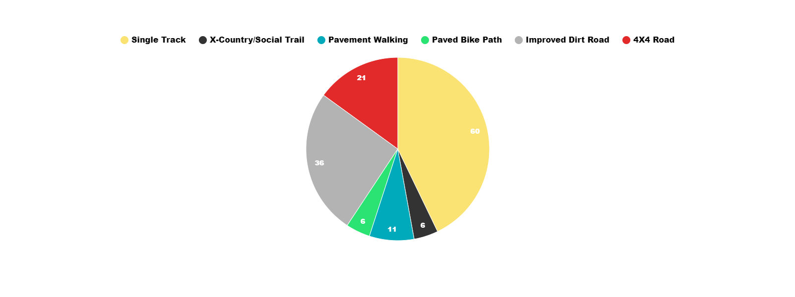
- The route is ~140 miles long with approximately 21k +/- feet elevation gain. The jaunt follows bike paths, single track, ATV track, jeep/dirt roads, cross country(ish) social routes, and about 11 miles of pavement in three chunks of 3-4 miles each with a one-mile road walk near the Moab terminus. Some stretches take in old “ghost roads” found only on some open-source maps and some short but manageable, off-trail hiking near Grandstaff Canyon. My track ends up as a somewhat rough trace in those areas.
-
-
-
- The Moab terminus of this route is at the footbridge over the Colorado River adjacent to Lions Park. This hub is 16 miles from Canyonlands Airport and three miles from downtown Moab. See my “Quick and Dirty Guide to Moab” for Moab (mile 0 or ~140) amenities such as lodging, outdoor stores, grocery stores, etc.
-
-
-
- The Grand Junction terminus starts at Riverside Park and along the Riverfront Trail and is located 8 miles from the airport. Lyft/Uber makes it easy to get to and from this point. A more prominent regional hub with many grocery stores, lodging options, and even an REI (among other outdoor stores). Google is your friend for GJ!
-
- .
-
- As for the mileage breakdown of the route, this pie chart should answer the questions :
-
-

Grand-Moab Route mileage numbers
What does this mean?
-
-
-
- Singletrack means hiking trails and mountain bike trails, and the lightly used dirt bike or 40″ ATV trails. Those used to a well maintained and defined National Scenic Trails may wonder about putting trail types in the same bucket. However, the single track (except the Porcupine Rim during peak season and hours; I saw no one on my walk) gets little use and is narrow enough to feel like hiking trails.
-
-
-
-

Along Porcupine Rim
-
- Social Trails/X-Country means routes that aren’t defined or on abandoned roads.
-
-
-
 .
.
-
- Paved bike paths make a self-explanatory term.
-
-
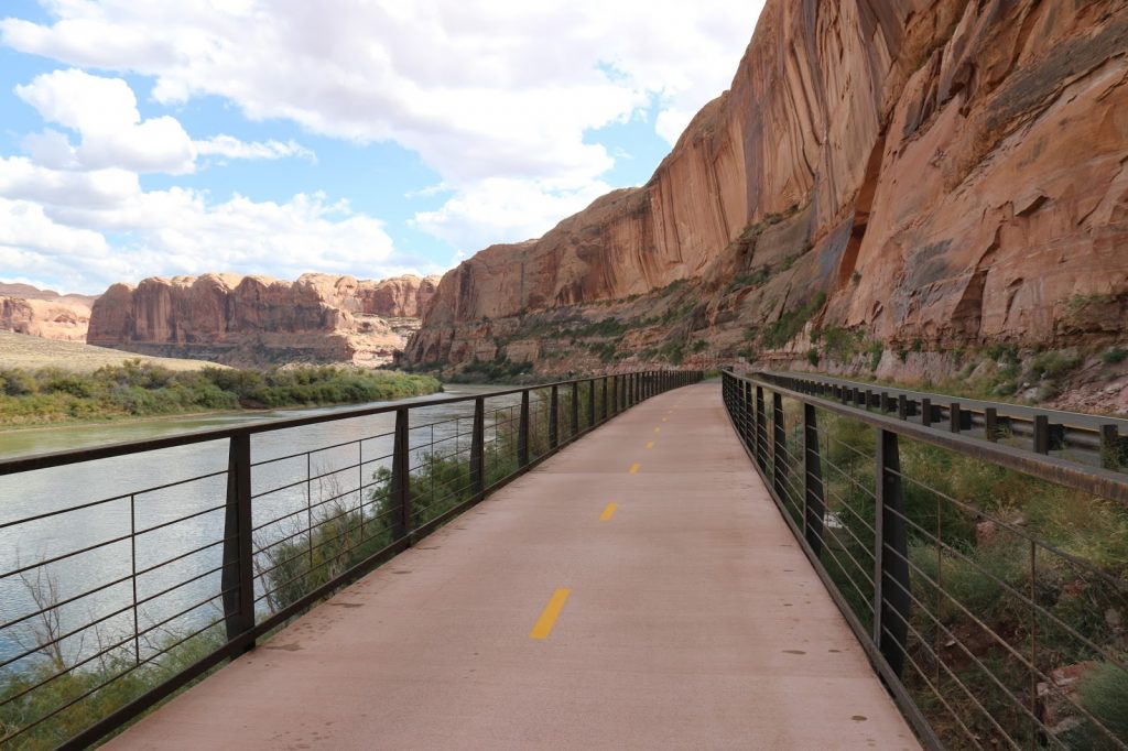
The final bike path you follow into Moab. From GJ Hikes.
-
- 4×4 roads make a distinctly different walk than improved dirt roads. The typical arc of these roads, I find, is that the start is OK for something such as a Subaru and then deteriorates into something you may want to drive with a Tacoma. Finally, these roads get so rough that it may as well be a trail unless you have an expensive non-stock Jeep and don’t mind cutting blowdowns. These roads are more trail-like than traditional dirt roads and typically have little or no traffic.
-
- .
-

Technically an open road in the La Sals. From an earlier trip.
-
- Improved Dirt Roads can typically get traveled by something such as a Honda Civic with care at times. Traffic depends on the time of day or if it’s a weekend but typically runs light to moderate-light.
-
-

 .
.
-
- Paved road walking is a slight overall amount and broken up into sections. The road walk between Castro Draw and Gateway ended up as a pleasant and rather pretty walk despite the pavement.
-
.
-
 .
.
- Speaking of which, there’s a logical resupply in the tiny hamlet of Gateway, CO. This “town” at the foot of the La Sal Mountains is near the UT/CO border at roughly 85 miles from the Grand Junction start (55 miles from Moab). This spot breaks up the food carried in either direction quite well for anyone who comfortably hikes at least 15 miles per day.
-
-
-
- This stop features a small convenience store/gas station, a post office, and a grill in the costly resort. The grill’s in line with NPS concessionaire prices in places like Zion, as the coffee shop. The other meals get correspondingly more expensive. Lodging is available for a lot of $$$$, of course. Sick of hiking? You can check out the classic car museum!
-
-
-
- Manns Peak is the literal high point at 12272′, with the AICC in Moab at 3990 for the lowest point.
- Speaking of which, there’s a logical resupply in the tiny hamlet of Gateway, CO. This “town” at the foot of the La Sal Mountains is near the UT/CO border at roughly 85 miles from the Grand Junction start (55 miles from Moab). This spot breaks up the food carried in either direction quite well for anyone who comfortably hikes at least 15 miles per day.

Near the summit of Manns Peak
Is this route a hiking version of the Kokopelli trail?
While superficially similar to the well-known Kokopelli Trail, this route takes in different areas, goes higher, and through areas where bikes aren’t allowed. Other than a brief two-mile stretch outside the La Sal Mountains, this route does not follow the “Koko.”

What about water?
Almost all the water carries are fewer than ten miles. There are two exceptions – East Creek to Dominguez Canyon of 19 miles and another stretch from just outside the La Sal Mountains to Grandstaff Canyon of 16 miles. Otherwise, ponds, springs, and creeks provide convenient water sources for an experienced backpacker, especially if you can comfortably dry camp.

Optimal seasons for this route?
Of course, it all depends on the snowpack in the La Sal Mountains, but you’ll not want to start this route any earlier than around mid-May or so during a typical year. That, of course, means hotter weather but a reasonably tolerable high of 80F for the acclimated and experienced desert rat and those temps at the last push into Moab itself (or start). Grand Junction has similar, if slightly cooler, weather. The Uncompaghre Plateau portion, sitting at 8-9k feet, will be somewhere between these two extremes of the desert and the mountains.

Mann’s Peak, May twenty-fourth, 2022.
Local mountain bike shops will post trail conditions aimed at mountain bikers wondering about La Sal Mountain trails but valuable for hikers. For example, hikers do not have to worry ,as much, about lingering snowy conditions.
You’ll want to check the conditions for:
-
-
- Burro Pass
- Hazzard County
- Kokopelli/Jimmy Keen
- LPS (Lower Porcupine Singletrack) and UPS (Upper Porcupine Singletrack) sections of the Porcupine Rim Trail
-
These trails and areas form part of the route you’ll hike and give a good snapshot of both May and post-October 1st conditions.
By June and into early September or so, you’ll routinely see temperatures well over 100F on the desert floor of both Moab and the Grand Junction area, and I do not suggest doing this trek during that time.

Don’t do it. Please.
You could start in late April/early May with a lower La Sal route option if you do not like the heat. The route is still scenic if about 2000′ lower. The lower route option ends as 3 miles longer from where it breaks off from the Higher La Sal Mountains option.
A highlight of this option, in my opinion, is the delightful Bull Canyon (Fisher Valley) Overlook with its grand views and the dinosaur fossils.

Dino tracks just after a rain storm. PCO Joan.
The lower route also takes in some scenic valleys with the snow-covered La Sals above and is a favorite place for some early season, higher country hiking for Joan and me.

Fisher Valley Overlook.
On the other hand, I’d hike in mid to late September if you can wait. In addition to fewer people, you’ll have optimal weather in the lower elevation sections with delightful fall weather and peak fall foliage in the La Sal Mountains.

If you wish to hike around or after October first and the first snows, the lower La Sal Route option also makes a potential choice.
Why Grand Junction to Moab or visa-versa?
Joan dropped me off in GJ, and I hiked home to my very door. A no-brainer for me!
For others, some considerations:
Though Moab has a small airport with flights to Denver and SLC daily (and some car rentals), Grand Junction has a larger airport and is more of a regional hub for all forms of transit. More car rental options, Lyft/Uber options, buses, and even trains.
To start in Moab is probably more manageable as you can use shuttling options if you fly into Moab or even from GJ (for a price) to the Lions Park.
As of Dec 2021, there’s now a bus service from/to Moab and from/to SLC and other area places for just over $50.
You could use the $1200+ luxury train from Denver with unlimited funds!
Leaving a car in Moab is also possible, as is Grand Junction (hotels, airport parking, storage areas.). Lyft/Uber is sporadically available in Moab but with taxi/shuttle options.
Going from Gateway to the La Sals means over 8000′ gain with three days of food +/- in almost one push, whereas going to Grand Junction, though more food overall, is not as a big climb at once.
On the other hand, ending in Moab makes a more scenic ending overall, in my opinion, vs. the edge of Grand Junction in a light industrial area. However, finishing in Grand Junction means your last two miles puts you a mere 700 ft from the Edgewater Brewery. 🙂

Close to the Moab terminus, and with a quick side trip, lies Morning Glory Bridge.
How difficult is this route?
For an experienced backpacker, this route is not hard at all.
The food carries aren’t onerous, has reasonably abundant water, and has straightforward navigation. It is not a connect-the-dots experience of the Appalachian or Pacific Crest Trails. Still, you should not find the route difficult for a person who can read a map, know which trail to take, and make intelligent decisions about where to camp and when and where to grab water.

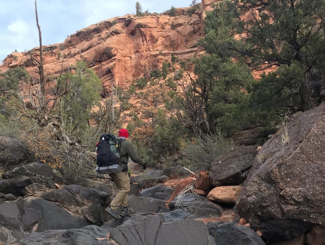
Exiting from John Brown Canyon just outside of Gateway, CO
Who might want to do this route?
A two-part question!
The logical person this route may appeal to:
-
-
- An experienced backpacker looking to see the relatively lightly visited places between Grand Junction, CO, and Moab, UT
- A Hayduke hiker looking for an “expansion pack” from or to Moab or wanting to avoid the logistics of Arches National Park. This route and the Hayduke meet not far from Courthouse Wash.
- Anyone doing a variation of Jamie Green’s border-to-border Utah walk who doesn’t mind a relatively easy 4 or 5 days of additional hiking to get to Grand Junction from Gateway, CO.
- A scenic alternative to the Kokopelli Trail for ADT hikers (Thanks to Bob Palin on the Hayduke group for this idea)
-
But the type of a person it may appeal to is someone looking to explore this land and see how it connects via the many old travel paths. And, naturally, enjoys the lightly visited and subtle nature of this terrain.

In Dominguez Canyon
This route reminds me of the New Mexico walk I did back in 2019 in many ways. Meaning it is a route for someone who loves the land in which the path travels. The La Sals are much like the Pecos in that they are beautiful mountains but not a marquee destination such as the Wind River Range, and the canyons you go through do not have the #hashtag fame of nearby Arches or similar.

Viewing a sunset not far from the Dominguez Canyon entrance.
It is a route for someone who loves this part of the Colorado Plateau, how it all connects, the history of the area, and the cultural landscape of the terrain. If you enjoy walking and immersing yourself in a memorable area, you’ll enjoy this route.
Permits and red tape
You do not need any permits and only need to sign in at trailhead kiosks in a few places. Very few camping restrictions overall. Be mindful of the private/public parcel mix near the CO/UT border for a short stretch. You do need to purchase a $2 day pass, via a QR code at a signpost with your smart device, for the Sand Flats Recreation area.
There’s a 16 miles stretch between Grand Junction and Unaweep canyon, where you can’t camp. Most of the start (or end) is along bike paths, mountain bike tread, or roads, making for easy walking. Otherwise, you can shorten this stretch to twelve miles via an alternate route.

Along the Gunnison Bluffs trail.
You need to use a wag bag for solid waste during a thirteen-mile stretch in the Dominguez Canyon area. However, there’s a pit toilet at the north end of this stretch.
Additionally, Grand County (Moab) requires the use of wag bags as well. The savvy backpacker could use the privies along the way. May want to carry a wag bag just in case. Lion’s Park, near the Moab terminus, contains facilities as of 6/1 for proper WAG-bag disposal.
Navigation
I don’t have a GPX file to share. An experienced backpacker who plots their own routes should have no trouble creating one based on the areas listed below. With the print maps and tools like CalTopo, Google Earth, and Gaia GPS, you can piece together an engaging and satisfying ramble.
For the overview print maps, and in many ways, all you need to hike the route, the following maps suffice:
-
-
- A print-out, using the mapping software of your choice, of the “Open Street Map” layer from the Grand Junction terminus to the start of the Dominguez Canyon Wilderness Area
- NatGeo #147 – Uncompahgre Plateau North
- Print out of Castro Draw on 141 to the UT/CO border using the USFS 2016 map.
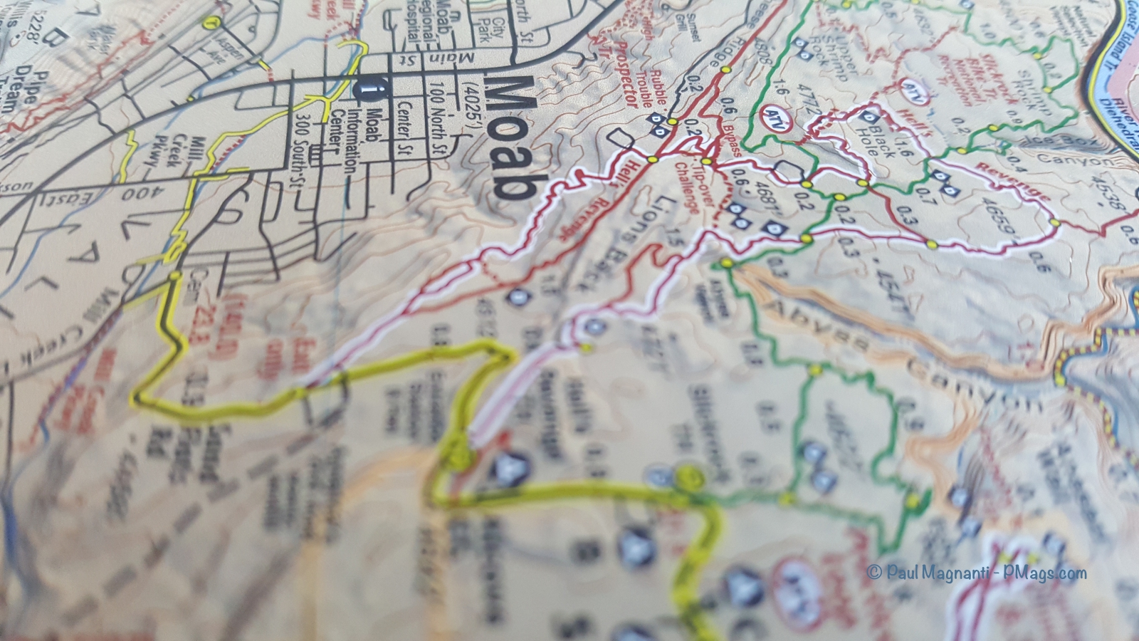
- Lat40 Moab East
-
I should add, while this route is not difficult, it is not a connect-the-blazes experience of the AT or the PCT. Additionally, it often goes through some delicate terrain with biological soil crust, and it goes by a fair amount of historical sites. A backpacker should be experienced in connecting trails, reading a map, planning resupply, managing water carries, camping with little impact on this terrain, and the appropriate ethics for archeological sites.
If you are an experienced backpacker and attuned to the ethics of this unique region you will find the journey an interesting one.
As a more extended overview –

I already shared a map photo. Here’s a picture of a grouse in the Uncompahgre Plateau section instead.
Navigation – Print maps
I found these maps the most accurate for the bike paths and routes that lead up the Dominguez Canyon area.
Though the NatGeo maps, rightfully so, often get a reputation of inaccuracy in recent years, this particular map proved the most accurate for the area. This particular NatGeo map lists the existing trails and old (often faint or mere indication) pack trails that other maps and electronic layers do not. As generations of people walked these paths, I found it a bit surprising.
If you do not plan to return to the Dominguez Canyon area, printing out the OSM and USFS 2016 maps with Caltopo will suffice for this trip.
-
-
-
-
- The USFS 2016 layer for Castro Draw to the CO/UT border printed out
-
-
-
The USFS 2016 layer had the needed detail to fill in the gap between these points. I used CalTopo to generate the appropriate map.
The Lat40 Moab East Map is the best print resource from the Colorado/Utah border to the Moab end of the trek. The folks at Latitude 40 continually update and ground truth in their maps, and their maps never disappoint
As before, printing maps with Caltopo will work well if you don’t have a use for this print map and would rather not spend the money. A mix of the USFS 2016 and the OSM layers also works best.
Electronic navigation
I used Gaia GPS with its ability to have many different map layers available easily along with a superior user interface compared to other apps, in my opinion.
And because I enjoy using the Lat40 Moab East map from the Utah border and into Moab, I switched to the Avenza app with a purchase of the electronic version of the Lat40 map. I often hike in the Moab area for some reason (!) and frequently use this map.
You can also purchase the NatGeo layer for Dominguez Canyon in the Aenza store.
The Avenza store has many free or low-cost maps that work for this route. However, you’ll need to switch resources depending on the location and your needs in a particular area, and the mix and match of maps could get unwieldy.
Though I quite enjoy the Caltopo desktop too for planning, I find their app not entirely to my liking in terms of the UI and features. In particular, I find that the interface for downloading maps could use some refinement, and it lags slightly with larger tracks.
.As mentioned, I did use Caltopo to make waypoints with notes to sync up with my account. Just not for navigation. However, the app works well enough, the price is competitive at $20 a year for strictly end-user mobile use and map printing, and the OSM and USFS 2016 layers work well for this route if you’d rather not spend money on or use additional navigation tools.

Gear and tools
My gear has not fundamentally changed much for solo trips over the years. You can read, more or less, the current iteration on my gear list page.
The gear I liked and used in particular:
-
-
-
- My ULA CDT continues to be the workhorse pack for solo backpacking, with many days on it by this point in time. Rugged, dependable, hauls gear and water well, and more than a one-trick-pony as with many frameless packs used for smaller food carries.
-
- .
-
- The Montbell Down Sleeping Wrap #2 is a comfy, cozy, and warm quilt that works well for various temperatures and can seal up almost sleeping bag-like for colder conditions. Perfect for going from the desert-like conditions at the start, up to higher elevations of the Uncompaghre Plateau and the even higher La Sal Mountains, and then back to the desert floor of Moab.
-
-
-
- I’ve tried different water systems over the years, but the simple but effective setup of two 1.5 liter bottles and a wide-mouthed sports drink bottle works best for my Colorado Plateau jaunts. I mixed it up on this trip slightly, and one of the 1.5-liter bottles ended up as a canola oil bottle. Worked awesomely! I use canola oil to season my cast iron skillets. The bottle is squarish and packs well, and has a wide mouth for easy filling. Winner!
-
-
-
- On the first day starting at Grand Junction, I found myself in cold and drizzly weather. The LightHeart Gear Rain Jacket, with its generous, almost anorak-like cut and pit-zips, let me hike in this weather without overheating. For $125, a well-made piece of gear that’s reasonably priced.
-
-
-

On the banks of the Colorado River at the confluence with Gunnison.
-
- I am down to my last two pairs of Salomon X Ultra 3s. 🙁 Still, my favorite shoe, and it handled the mixed terrain of this route well. I’ll need to start looking for a new shoe, as I hear the Ultra X 4s do not work nearly as well, and maybe a different shoe.
- .
- Finally, my Western snap, poly-cotton blend shirts tend to work well. Loose for ventilation, breaths well, blocks the sun, comes on and off easily, dries quickly, and is comfy.
-
-
.
An October 2021 trip I took with Joan in Dominguez Canyon. You’ll hike right by this wash that leads to Dominguez Creek and a pretty campsite. I take different gear solo than with Joan. PCO Joan.
- I mapped out and made notations for this route with Caltopo. Hands down, the best desktop interface for creating routes, using many different features, and printing maps.
In the field, I quickly made waypoints with notes with the Caltopo app, and it automagically synced up with my account once I came online again. At home, I tweaked the route to reflect the reality I found on the ground.
My personal experience

I am starting a new remote IT job on June first and had some time between gigs. Though I initially thought of hiking this route in the fall, I’ve planned this route for a while. When the gift of time presented itself, I found myself ready.
The many weekends Joan and I went on meant my gear had extensive field testing, and my system dialed in. Perhaps more importantly, I committed to overall fitness these past 2+ years. Meaning I could do the mileage I wanted from the first day. I started on May twentieth at 11 AM and finished at noon on May twenty-fifth. I don’t believe in getting fit on the trail; I want to be fit to enjoy the trail when I’m on it.
I found the variety on this trip, esp. for a relatively short route, astounding. I started in wetland-like areas along the rivers, went through high-desert environments, over the aspen and pines of the Uncompaghre, and then up to alpine habitats of the La Sal Mountains. And then, the same day, I found myself on a high desert canyon rim and hiked down into the canyon to end at the Colorado River.
I found it neat to walk back to my house for an additional 1.5-mile-long section hike along the Hayduke as well!
I hit the weather window about right. The weather, overall, stayed on the cool side. On my last day, I had 80F degree temps in Moab. By the weekend, it climbed into the 90s! Though I found snow above 10k ft in the La Sals, especially on north-facing treed slopes. I did not find it overall difficult as the navigation did not prove problematic since the trail followed a drainage in any case.
Overall, I saw few people.
I had the Porcupine Rim sections to myself, only briefly saw some “KoKo” bikepackers, only two people in the La Sals, four in the Dominguez Canyon (and only near the campground), and only I saw one truck on a 4×4 road. On the Plateau, I only saw a handful of people as well. The paved road walks had some traffic, but very light. Johns Brown Canyon had some traffic, but I hit it on a weekday and did not find it onerous. I shared the Gunnison Bluffs with a total of one bicyclist.
Only on the paved bike paths did I find a moderate number of people, and those sections have brief walks on either end of the route.
The scenery proved memorable on this longer walk and on past weekend walks in the area.
The Gunnison Bluffs made for a scenic highlight, which I had never seen before. And it’s been some years since I walked the Porcupine Rim. The views impressed me again!
Overall, I found the route an interesting way to connect Grand Junction and Moab logically. And based on the historical evidence found throughout the route, the route takes place where other people traveled long before me.
Here are some photos from the walk from Grand Junction to Moab.
Grand Junction and through Dominguez Canyon –
The confluence of the Gunnison and Colorado Rivers.

Mural along the Riverside bike path.

Crossing the river over a footbridge

Along the Gunnison Bluffs

Along the Tabeguache Trail

Sego Lily

Cactus Park

Overlooking Dominguez Canyon. You can see Grand Mesa on the horizon.

Claret cup cactus
Views from the Uncompaghre Plateau –


Views into Unaweep Canyon –


First view of the La Sal Mountains –

Dropping towards Gateway –


Old cabin


Butte outside of Gateway, CO
And to and through the La Sals –

Near the top of the climb of the canyon.


Uranium mining and processing form a part of the area’s history a surprising amount of people do not realize.

CO/UT state line


Summit of 12272′ Mann’s Peak

Desert floor of Moab 8000′ below

La Sal Mountains to Moab –


Castle Valley below


Looking back to the mountains where I summited in the morning.

Time to drop into the canyon


Along the Colorado River and near the end of the trip.

Matrimony Spring(s) – Where local legend has it that those who drink its waters will always return to Moab. Much evidence of Pre-Columbian use.


Mandatory finish photo. Here I am at a crossing generations of people used and will use long after me.
Bravo Paul. What a cool adventure!!
Paul – what a grand (no pun intended) adventure!
I am traveling to Colorado from NC later this week and had my eye on staying a few nights at the BLM campground at the top of Dominguez canyon. Do you think temps at that 7,000 elevation and the upper canyon would be manageable around the 21st of June? Or should I just head to Grand Mesa?
I think it should be comfortable at night and tolerably warm during the day. Have fun!
Thanks, Paul. My soul needs to hear Canyon Wrens.
First off, congratulations. Second, WOW! You’ve connected so many of the places I love, and have traveled through, into one grand adventure. This is something to be proud of. For several years I’ve wondered how I could walk from my home in Fruita, CO to Moab that was NOT the Kokopelli trail. This article really has me inspired now. Thank you so much. And thank you for not posting too many details.
Thank you! I think some neat varaitions could get made with Colarado NM, Bangs Canyon, and more. Such great areas.
Thanks Paul on behalf of all hikers for this huge body of information. I live in Australia and follow your site for the great photos trip reports. Best wishes
My pleasure!
This is amazing. Moved to Grand Junction a couple years ago and have been looking for something like this. Any chance you have the full GPX file of the route? I’d love to do this.
I do not have a GPX track to share at this time. With the info I gave and with tool like Caltopo or Gaia, you could make a GPX track of your own. Have fun!