My experience backpacking on the Uinta Highline trail in Utah. With trip planning and logistic info.

Want to skip directly to the planning info? Click here!
The Highline Trail in the Uinta Mountains of Utah, often called the Uinta Highline Trail (UHT), captured my imagination since someone, and I took a trip to the nearby Dinosaur National Monument this past Memorial Day Weekend. Looking from our vantage point on a trail, I could not help but think about these mountains that form a definitive boundary on the Colorado Plateau.

Distant view to the Uinta Mountains from the Rupple Point trail in DNM
The Uintas are one of the few East-West ranges in North America, contains the highest peak in Utah, has more above contiguous above tree-line terrain than any range in the lower 48, along with the San Juans of Colorado, but is a lot less visited.
I was intrigued.
And I wanted to hike it.
As I did more research, I found that there is a trail that traverses this range and is not quite 100 miles. About right for my annual week-long vacation, I get to take for myself.
The logistics of a trek would not only involve a long drive but a massive 160-mile long shuttle between the two termini of the trail (more info below on logistics).
Luckily, my good buddy Mark had taken the summer off after working a contract performing microchip design. He was now was finishing up his Canadian climbing/hiking/backpacking adventures by driving down the Rockies back to his Colorado home. Mark was also intrigued by the range and was happy to join me.
Joining us for the trip would my friend Andy (Garlic), who had just moved back to Colorado after five years in Arizona.
Shuttling logistics assured, we made plans to meet up near the Hayden Pass TH.
Garlic and I drove up from Colorado and met Mark in Evanston, WY, not far from the Utah border. The following morning, we parked Mark’s car at the Hayden Pass trailhead, piled into my vehicle and ~3 hrs, and 160 miles later, we arrived at the eastern terminus of the UTH. The trailhead was just up the road from Vernal, Utah, on the very well-traveled Highway 191.
Now, I should say that our choice of starting at the far eastern end of the trail was unusual. Most people who hike the trail start at two other trailheads that make for an ~60 miles or an ~80-mile hike.
The ~80-mile option starting at the Leidy trailhead was briefly considered, but we all concluded that we would instead hike more and drive less. The Leidy Peak trailhead option would mean a lot more driving. Roughly 120 miles and ~2.5 hrs more of driving total.
Starting from the TH near Vernal, UT also made logistics for the end of the trip easier as this trailhead was just off a major road and was also on our way back to Colorado. Naturally, the ~60-mile option seemed to miss some scenic chunks of above-treeline hiking. And, at least according to Google Maps, even more, driving time and miles driven than taking the longer hiking option!
So, more hiking and less driving with easier logistics seemed to make far more sense. 🙂
Enough logistic info. Time to hike!
We parked my vehicle at the sparsely used TH in the pine and aspen forest surrounded by low, wooded hills.
We were barely out of sage country and at the very start of the Uinta mountains.

For a brief period, we were on a shared ATV trail. No ATVs were in sight, but the rocky and rutted trail showed that ATVers did come through at least on occasion.

The trail did have one of the coolest emblems of any path I’ve seen:

The trail started paralleling the road. So we decided to hike CDT-style and just hike the road! 🙂 On this quiet day, it made logical sense.

Eventually, it no longer made sense to road walk. Above Lonesome Park, we joined the trail proper again. Well, relatively speaking:

From this point to the Leidy Peak TH, the trail would be series of connect-the-dots to find the trail. Cairns, the occasional orange diamond, old-school axe blazes, fresh cuts on blowdowns, and new flagging marked the way. There was obvious and new trail work done this past summer. We were all grateful for the work done by the anon. trail crew. Otherwise there would be many blowdowns and difficult trail to follow.
(EDIT: The trail crew in question is the very active Uintah Basin Back Country Horsemen group. They do great work. Check out their active Facebook group, too. THANK YOU FOR THE HARD WORK!!! )

Mark trying to convince me he found some REALLY high elevation trail markers. 😉
From a high point on this section of trail, we caught a view of what looked to be the first above treeline peak on the UHT going westbound – Leidy Peak.

The high country was not much further!
After about 15 miles of hiking, we made our camp at the edge of Summit Park.
Though this section of trail was not dramatic, the wide-open meadows were very pretty and well worth the hike.

Just before the Leidy Peak TH, we took our breakfast at a ditch that looked to be remnants of old ranching days.

Shortly after our break, we made it to the Leidy Peak TH. Though on a well-graded and improved dirt road, there were hardly any signs of widespread use. My thoughts that we would be seeing more people once we made it to this TH did not hold to be true so far.
Once past the TH, the terrain also immediately opened up to rolling tundra.
We had arrived in the high country!

Mark and I love off-trail hiking. And the gentle terrain with the apparent ridgeline was too good to pass up. So off-trail, we went.


At one point on our route, we could see Flaming Gorge. The obvious, glacier-formed valley, reminded me of a mini-Glacier National Park.

Shortly after we joined the trail again, we saw our first hikers. We would not see any hikers until the Kings Peak area many miles up the trail.

The blue sky was replaced by an overcast day, but the terrain was still pretty.
We soon reached Chepeta Lake. From this point forward, there would be no road crossings on the UHT from now until Hayden Pass.

We made camp, and it rained during the night.
Blue sky briefly peeked out the following morning. The optimist in me hoped it was a sign of a good weather day to come.

We approached North Pole pass. The large cairns reminded me of photos I’ve seen of Japanese pilgrimage routes.

Once at North Pole pass, the weather moved in.
The gray and drizzly weather gave the mountains a Pacific northwest feel.

We briefly had talked about going off-trail again at North Pole pass, but the uncertain weather and above treeline exposure made us stick to the UHT proper.
We descended back into the trees and quickly spotted a young bull moose just off the trail.

The wide open valleys of the sub-alpine areas were very beautiful to hike as well.


Through this day, Mark seemed to be in pain. We first thought it was some ankle injuries, but it turned out to be a case of shin splints. 🙁

All three of us decided to make camp shortly before Painters Basin. Mark would take some “Vitamin I” and use some ice-cold water in a ziplock bag and see how he felt the following morning.
The following morning, we hiked to the aptly named basin.
Though there were low hanging clouds above the high peaks, the area was still astonishingly beautiful. I took numerous photos in this area:


See? 🙂
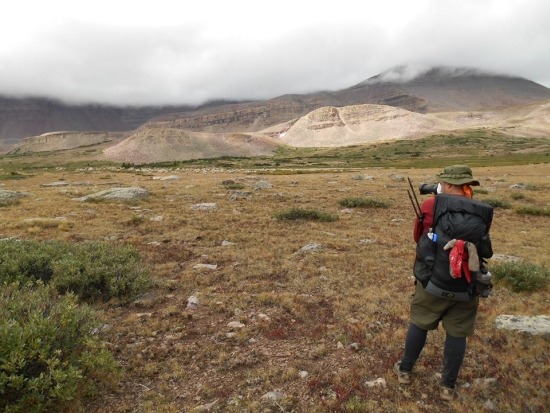
Photo courtesy of Mark Thomas
Alas, despite all the beauty, a decision had to be made.
Mark was not healing and was grimacing as he walked. The terrain was about to get more difficult. And a major side trail joined up and lead to a TH that had spots for 50 people according to our Trails Illustrated map. For my own part, my left ankle was still tender from twisting my ankle while rock climbing about a month prior. It rolled, painfully, twice in the past few days.
The decision was made: I’d hike out the ~15-mile side trail with Mark. We’d hope to get a ride to Evanston where we’d wait for Andy.
Andy would power hike back to the car at Hayden Pass (~45+ miles) and drive back the following night.
Andy said his temporary goodbyes. Mark and I headed off on our own. (Andy’s account on the UHT past Painters Basin is included further below. He gave me permission to quote his trip report).
Just before we veered off the UHT proper and up to Gunsight Pass, we enjoyed some looks to the fog-shrouded Kings Peak and caught a glimpse of the rugged country that awaited Andy.


Once over Gunsight Pass, we entered an expansive meadow. One of the largest that both Mark or myself had ever seen.

We sat there for quite a while. The sun had come out in the valley, and it felt good to be warm and dry. As we were drying out our gear, we looked up the clouds hanging on the high peaks above. We wondered about the journey Andy was currently experiencing.
Eventually, we moved further down the well-graded and obviously well-used trail.
Tents were spotted, people were seen, and a herd of sheep was grazing in the distance.
The Henry’s Fork trail was the shortest way to get to Kings Peak (but still ~20 miles one way from the TH), and it showed.
Our trail took us along the river, and a camp was made in an area that had the always comforting river sounds to lull us to sleep.

The following morning we made the short hike out. A moose cow greeted us just off the trail.

Soon after, we reached the Henry’s Fork trailhead. A gentleman dropping off his son-in-law and grandson for a backpacking trip was kind enough to offer Mark and I a ride to Evanston, WY, since it was on his way to Salt Lake City.
We did not realize how far off the beaten path we were. We drove through several types of eco-zones and ended up in sagebrush country.
Perhaps ninety minutes later, we were dropped off at Motel Six. We thanked the gentleman (who not accept our gas money), grabbed a room, and I started having flashbacks to my thru-hikes:
- A big breakfast calorie gorge at the diner across the street
- Laundry completed
- Showers were taken
- Supplies bought at the truck stop and gas station next to the motel (razor, a cotton t-shirt, and beer. Natch)
- We kicked back, relaxed and discussed the next plans
In the meantime, Andy was having an adventure of his own:
Day Four—Injury and Plans Change
It was soon apparent that Mark’s leg was going to be a problem. The slower pace and night’s rest did not help. We had enough food for three more days of hiking, with about forty-five miles left. But we were not keeping a 15 mile per day pace. So Mags, our leader, came up with a plan. He and Mark would hike very slowly out over nearby Gunsight Pass, about fifteen miles to a developed trailhead at the Wyoming border. I would continue out to the car at a fast pace, hopefully two days, then drive the car around to pick them up.
West of Anderson Pass and Kings Peak, the Uinta Highline Trail changes character. The broad ridges and passes of the east change to rugged notches and arêtes. The trail crosses the divide many times to find a hiking route among the rough country.
We said our goodbyes and I took off, heading straight up Anderson Pass, at 13,000’ the high point on the trail, and the first of six remaining high passes on the route.
Solo Hike
It has been over two years since my last long distance, multi-day hiking trip. In recent years I’ve been concentrating more on bicycling. I’m in good condition, but not trail-hardened. I was hoping for a certain amount of “muscle memory”, some skill, and a little luck. The muscles cooperated, but the skill and luck didn’t completely.
Rain showers continued again most of the day, but I had some clearing at Anderson Pass and could barely make out the summit of Kings Peak. On a nice, relaxing day I would have scrambled the five hundred remaining feet to the summit. But not today—it was neither nice nor relaxing. I was concerned about my friends, and my ability to hike the next 45 miles in two days. And storm clouds were rolling in from the valley in front of me.
Anderson Pass was simply stunning. The trail on the far side of it is perched atop a cliff over 1000’ above the valley floor. The trail traverses the cliff to a steep scree field, then switches steeply back and forth to make the descent. I took the scenery in among swirling clouds and rain, thankful again for no electrical activity. It was simply breathtaking up there.
I was further amazed by the Yellowstone Creek valley below. South-facing snowfields, rare in the mountains this season, lined the bottoms of red cliffs and waterfalls were cascading over those cliffs. I took the time to take a bath, do a little foot maintenance, and soak in the scenery.
Next came Tungsten Pass. It was an easy climb, maybe too easy. And here I met the only person I would see on the trail between Anderson Pass and the trailhead, a backpacker eating his lunch and contemplating his approach to Kings Peak. My attention flagged a little and I took a wrong turn at its base. I made a mistake and my luck ran out. I noticed I was going in the wrong direction, but somehow justified it during a map check. No excuse, but the map covered a huge area at a very small scale, and contour lines were 100’ apart, making detailed navigation tricky. There were no trail tread or signs in this remote back country, either. I finally reached a distinctive lake that told me I was two miles and 500 feet down the wrong route. I cussed a bit, but immediately turned around a started a fast climb back up.
That mistake cost me nearly two hours in a tight time frame. I was really disappointed in myself. I rarely make navigation errors of that magnitude, and why now when an injured friend is waiting?
The next pass, Porcupine, was a difficult climb back up back to 12,400’ and an equally difficult descent. This was my third of the day and fatigue was setting in. Very heavy recent rains had soaked the area and the trail tread had largely washed out, and the upper slope had slumped over the constructed benching. Like Anderson Pass earlier, this was a vertiginous route on a big wall. It was stunning, especially in the clearing evening light, but it was not as enjoyable as it could have been.
Navigation difficulties continued after the pass descent, in large open trackless meadows and marsh. I reached a busy sheep-grazing area with a network of animal trails. Thankfully, sheep don’t build cairns. I learned to triple-check map and compass often. I climbed several more minor ridges and made it to my original planned campsite in a high meadow right at sunset. Later, I found that Mags, looking at his map that same night in his campsite near Gunsight Pass, predicted I would camp at this exact spot.
I treated a couple of hot spots on my feet, and got a little concerned about the again-inflamed knee. On the other hand, I was pleased at my stamina and performance at the high altitudes of the day. I am not acclimated to 13,000’ anymore. I rested well that night.
Day Five
The next day I arose in heavy fog, soaking wet, ready to tackle three more passes. The knee felt OK, but muscle fatigue from yesterday did not completely vanish. The first pass, Red Knob, had a very difficult map-and-compass approach in foggy marshland. It is hard to connect the dots when you can’t see the dots. But the weather cleared for the final pass ascent and again, I was stunned by the views to the north.
It was a quick dip below treeline to Dead Horse Lake. Then came the eponymous pass, which lived up to its name with pieces of a horse skeleton easily seen from a switchback. Dead Horse Pass was the scariest pass I believe I’ve ever hiked. And there’s a warning note on the map that the pass is not suitable for pack stock. The recent flooding rains made a difficult hike nearly dangerous. A slip would have been fatal. I tried to imagine hiking this with a weak ankle or shin splints, and was pretty happy with Mark’s decision to bail out.
Both Red Knob and Dead Horse Passes were over 12,000’ and the descents to treeline below 10,000’. I was then happy to see that the next and last pass of the day, Rocky Sea Pass, was only around 11,500’. Normally I wouldn’t care about 500’ here and there, but today I was fatigued.
The intervening trail got pretty good for a few miles, allowing me to make good time comfortably for a while. I forded knee-deep Rock Creek. I didn’t trust my wobbly legs and judgment to hop the large rocks or cross on the small tree. But after Rocky Sea Pass I was again faced with heavily used and eroded mud and rocks. The last six or eight miles out to the trailhead increased my fatigue to the point where I was lurching and limping when I reached the car. This was pretty close to my maximum effort. I made it out at about six pm, a couple of hours later than I had hoped.
______________
At 7 pm, the phone rang in our room; it was Garlic! Per our plans, he stopped by the Motel 6 in town first.
We were happy to see him. He was pleased to see us, take a hot shower, and relax after all his hiking. He seldom drinks beer but seemed to enjoy one that night. 🙂
The following morning, Mark and Andy offered again to shuttle me so I could complete the UHT. Though I considered it, all the time in town had me lose steam, and I wanted to see someone again. We made plans over the phone to make a trip together over Labor Day Weekend. The thought of taking advantage of this earlier finish time go on a trip with m pleased me. Guess I love the gal? 😉
We reached my car at the far at the end of trail and then had a late lunch together in Vernal. Marked borrowed my Utah maps as he was not quite ready to go to back. We said our goodbyes-for-now. Garlic and I made our way back home without incident.
Though the trip did not go as planned, it was still an enjoyable trip. About 70 miles of backpacking with friends is never bad. And the follow-up trip to the Snowy Range in Wyoming was enjoyable too.
Not a bad “end of summer” vacation. 🙂
LENGTH: The length of the trail from the Highway 191 trailhead to the Hayden Pass trailhead is a little over 95 miles according to an original version of this wiki article. If you decide to hike nearby Kings Peak (1.4-miles r/t), the trail is 97 miles total.
Why the mileage differences between sources? Because map traces vs. recreational grade GPS units will often disagree. Just call the trail ~100 miles in total, including Kings Peak, and you’ll be fine. 🙂
VERY UNOFFICIAL SECTIONS OF THE TRAIL: In my opinion, the Uinta Highline Trail can be divided into four distinct sections.
- Highway 191 to Leidy Peak TH: The first ~20 miles is in lower elevation terrain. The markings are sparse and require vigilant navigation. Luckily some recent maintenance in the summer of 2013 made this section of trail easier to navigate than in previous years. Not as dramatic as the more western locations, but the open meadows (called “parks”) were very pretty.
- Leidy Peak TH to Chepeta Lake: This approx 15-mile stretch is mainly on rolling tundra with a fair amount of lakes and wooded terrain mixed in. Much easier navigation and quite lovely.
- Chepeta Lake to Painters Basin: Another ~ 16-mile stretch where, like most high line trails, you go up to a high point above treeline and descend to a lake. The trail is rather dramatic in this area
- Painters Basin to Hayden Pass: The last ~ 45-mile stretch is the High Uinta Mountains proper. Rugged peaks, passes, and trails. Wide basins and quite stunning. All but the last few miles into Hayden Pass aren’t too well-marked. Mark and I had a small taste of this section; Garlic’s account validates this view in full.
HIKE OPTIONS:
- The ~60-mile option starts or ends at Chepeta Lake. You’ll see the High Unitas. The highlight for most.
- The ~80-mile option starts or ends at Leidy Pass. Rolling tundra type walks dominate.
- The entire ~100-mile stretch starts or ends outside of Vernal, UT, at the McKee Draw TH. Sagebrush in the lower Unita foothills dominates.
Now, I should say that our choice of starting at the far eastern end of the trail was unusual. Most people who hike the trail start at two other trailheads that make for an ~60 miles or an ~80-mile hike.
The ~80-mile option starting at the Leidy trailhead was briefly considered, but we all concluded that we would instead hike more and drive less. The Leidy Peak trailhead option would mean a lot more driving. Roughly 120 miles and ~2.5 hrs more of driving total.
Starting from the TH near Vernal, UT also made logistics for the end of the trip easier as this trailhead was just off a major road and was also on our way back to Colorado. Naturally, the ~ 60-mile option seemed to miss some scenic chunks of above-treeline hiking. And, at least according to Google Maps (link will not resolve in winter as an FYI) even more driving time and miles driven than taking the longer hiking option!
SHUTTLING LOGISTICS: Shuttling is the hardest part of this trip, IMO. See above about why we chose to start at the eastern trailhead. Others who have less time and/or can’t hike as many MPD may want to choose a start or end closer to Hayden Pass. Note that shuttle services come and go and may change from year to year.
As of Aug 2020, Mountain Trails Transport offers shuttle options from Vernal. Their website also lists how to get to Vernal itself. And, as of summer 2021, UHT Shuttle performs shuttles including from the SLC airport.
As of Dec 2021, Salt Lake Express has $50 bus rides from the SLC airport to Vernal.
Another option: If you are not averse to an easy hitch, “LBHikes” posted a possibility.
PERMITS: No permits needed to hike the UHT. However, a pass is required in order to park at the popular Hayden Pass TH. The Bear River ranger station on the way up to the TH on HWY 150 issues seven-day passes. If you have an intra-agency “America the Beautiful” pass, you can leave that on your dashboard instead or use the plastic hanger that is now provided.
NAVIGATION: For hiking the entire trail, Trails Illustrated Maps #704 and map #711 are suggested. If you hike from Leidy Pass TH or the Chepeta Dam area to Hayden Pass, #711 is the only map needed. For some of the trickier areas noted by Garlic, the appropriate 7.5 scale topo may be helpful. CalTopo has the route online if these maps are desired.
A free databook is avail at this link that takes in the Leidy Peak TH to Hayden Pass stretch. GPX files are available as well for those who wish to use a GPS.
For the eastern portion of the trail up to Leidy peak, the following two links are Garmin Adventure links for the appropriate tracks. Thanks again to Gordon Hirschi for this information.
http://adventures.garmin.com/en-US/by/mtch/highline-trail-eastern-section/#.V8SU3vkrK1s
If you decide to park a vehicle at the Leidy Pass or Chepeta Lake THs, a backcountry road atlas would be handy.
WATER: With over 2000 lakes in the Uintas, water is not a problem EXCEPT in the first stretch up to Leidy Peak TH. After that? Plenty of water. Pay attention to your maps for the first stretch. It is not terrible, but you have to gauge accordingly. A poster on Reddit recently (Aug 2020) added some info for a particularly dry section.
GEAR: Standard gear for hiking in the three-season Colorado mountains worked well. We all used trail shoes, some sort of tarp or tarp tent, and I even used a 25F quilt.
RESUPPLY: Based on inquiries and Google searches, it seems people are interested in resupply for this trek. There is no ready resupply. You’ll have to drive, perform a shuttle, or have generous friends and family members cache supplies and then pick up your caches after the trip. A lot of driving hours. 🙂 Leidy Pass and Chepeta Lake are the prominent places to leave a cache. Bear canisters or surplus store ammo boxes (less expensive; easier to transport) are the suggested items to use for caches. Do not use plastic buckets, bins, or similar for caches!
As a reader wrote:
If you take this [cache] method, please note that it is not okay to leave a bunch of flimsy Rubbermade bins in the forest. Bears will find your food and eat it. All.
If resupply is a concern, I’d suggest not hiking the whole route and use the 60 or 80-mile option instead. Much easier logistically. There would be a lot of driving vs. the amount of hiking, even at 10 MPD. At least in my opinion. If you are lucky enough to have people meet you at these remote trailheads to resupply you, thank them enthusiastically!
OTHER INFO: Check out the Highline Trail film!
POST TRIP NOSH: Evanston, WY is a small, compact town with a decent amount of amenities. We had some good Mexican food at Don Pedro Family Mexican. Reliable, tasty, and not expensive with good sized portions. No complaints from me.
If the trip had gone as planned, the Quarry Steakhouse and Brewpub in Vernal, UT, was spoken of as a good “beer and burger” place by the ranger office in town.
STILL WANT MORE TO DO?: Dinosaur National Monument is very close to Vernal and is worth a side trip after, or before, your hike if you have the time.
OVERALL IMPRESSIONS OF THE UNITAS: Beautiful, remote feeling and un-crowded mountains that have a unique feel. I’ll be back!
What a great trip you had. Could you tell me the month that you hiked the trail ,thinking of middle July or later in August. I have a blast hiking to the Morats on occasion but a friend and I are planning to do the whole trail this summer.
John
We hiked it in the last week of August. Good times!
I did this hike in 2012. Navigation is definitely tricky. The Uintas have lots of water which equals lots of mosquitoes. If that will deter you I recommend waiting to mid August. By then the mountains will have a had a frost to kill off the bugs.
This is a great trip report! Me and my fiancé hiked from Leidy Peak to Hayden pass first week of August 2013. It was incredible. Even managed to summit King’s Peak. This is an amazing thru-hike, full of huge vistas and true high country. Backpacker magazine reports less than 50 people a year complete the Highline Trail 🙂
I am a member of Uintah Basin Chapter Back Country Horsemen. We adopted the Highline Trail from hwy 191 to Leidy Peak Trail Head we started our work in 2013, the flagging was probably ours and we finished up last fall. We will returning next summer asap to make sure it is still open.
We are very glad to see it is being used and we are open to comments or questions.
Mr. Mags do you mind if use your comments on our facebook page?
Gordon, as I told Jody above, thank you so much for the trail work. I’ve swung a few Pulaskis, so I know the work involved. I’d be honored if you used my comments. Please do!
Really enjoyed reading about your experience. I’m a Vernal resident, and the Uinta Back Country Horsemen are the ones doing the maintenance on the Highway 191 to Leidy Peak Trailhead. Every year we clear a lot of blowdown, and have been working to make the trail less of a connect-the-dot experience. Glad to know the trail is being used, since we rarely see users!
Thanks for you and your group’s trail work! Made that stretch a bit easier for sure.
So I’m thinking of taking some high school students on this trail. In your opinion is this too difficult? Say it’s the big trip of the year and about a year prep gear and conditioning. I’m just fishing for ideas.
Without knowing your students’ ability level, hard to say. For most people, the sixty mile option I mentioned would be a challenging, but within reason, hike of six days at ~10 MPD. This is assuming previous backpacking experience. It is a good trail for someone with a moderate+ experience level in above treeline conditions.
Our back country horseman chapter is currently working on Uintah Highline Trail from Hwy 191 to Leidy Peak Trail Head for the third year and will finish this coming weekend. We also took on the Don Hatch Trail which goes from UHL/Hwy 191 then goes north then west, then goes past Red Canyon Lodge in the Flaming Gorge Recreation Area to the Manila Park Trail. My family has adopted this trail this year and will have it cleared on August 15th. The Manila Park Trail is a north-south trail connecting UHL with Flaming Gorge. When I worked for forest service… Read more »
Just moved to SLC and I have my eye on this trail. Great photos and details in the report! Any idea on best practices for food storage with so much of the mileage above treeline?
This article I wrote should help: https://pmags.com/bear-and-critter-concerns-what-to-do Happy Trails!
Thanks for posting this. I have read very few accounts of hiking in this area. I appreciate you taking the time. It’s on the ever-growing list of places. Glad to hear it’s not overrun by the unwashed masses.
Hi, I am hiking from the same starting point as you did. Could you tell me about water sources between the small lake around mile four from your start point to the Leidy Peak trailhead?
Mainly dry IIRC. The map will have the most definitive water sources marked. Tank up accordingly.
Comment: A week ago I was doing a log out contract for the forest service on high Uinta Highline Trail north west of Vernal, Utah Gabbro Pass west of Leidy Peak still is snowed in I suggest that hikers drop down and take Lakeshore Basin and pick up trail 0132 There is also a sign at Chepeta Lake Trail head that states Douglas pass is being worked on. If anyone has questions they may contact me
Hello Paul
I had a meeting this morning with Wilkins Bus Lines Inc. located in Vernal and they are willing to supply a shuttle service for trail users on UHT Uintah Highline Trail from Vernal, Utah(Highway 191 Trail Head) to Kamas, Utah( Mirror Lake) the contact for this service is Mr. Todd Wilkins 435-789-2476
The following two links are Garmin Adventure links which should complete GPS which should complete the eastern section of UHT
http://adventures.garmin.com/en-US/by/mtch/uinta-highline-trail-hwy-191-trail-head-to-north-east-park/#.V8SVh_krK1s
http://adventures.garmin.com/en-US/by/mtch/highline-trail-eastern-section/#.V8SU3vkrK1s
Wow..that is AWESOME news. I’ll add that info right away. Many thanks!
Hi Paul. I noticed you didn’t go into much detail regarding your gear. I also see that you are a BPL member so I assume you are into ultralight gear. Would you be willing to share your gear list? Also, based on your experience would you make any changes to your list?
Thanks. I’m looking to solo the Highline this summer and am beginning the preparations.
Thanks!
Frameless ruck sack. Tarp. No stove. Trail runners. Jack R better quilt. Sub-10 lbs.
What I use today. Very similar to this 4 year old list
https://pmags.com/mags-gear-list
I no longer use a windshirt and prefer a 100 wt fleece. I hiked in the fall so no head net or deet.
I don’t talk about gear because it is like cooking to me: The knife I use is less important than the meal itself. 🙂
I should also add my friends used/use different gear and are all equally experienced outdoor users FWIW.
Thanks for your insight. I’m always interested in varying perspectives.
This guy –> http://metalbackpacker.com/high-uintas-wilderness-utah-8-day-hike-aug-2015/
50 lb pack and 95 miles covered without a complaint. Lol.
I’ve had some pretty rough patches of thunderstorms in the Uintahs so I’m always trying to calculate that proper balance between comfort and safety. Most trip reports I’ve read from the Highline indicate (to me) that people underestimate the difficulty and conditions.
Yeah. Bummed about my buddies injury, but we made a good decision.bad luck! EDIT: Having said that, the conditions were no more difficult than other hikes I’ve done. My buddies injury was the real wildcard.
Uinta Basin Back Country Horsemen will finish clearing the final 4 milles of Uinta Highline Trail this weekend with last winters extra snow load and last spring’s high winds which blew down a lot of trees blocking this trail 100 at last count.
I met a young hiker from Canada on the trail that uses PMags I appreciate your work.
My work is pretty easy compared to what you all do. THANK YOU! 🙂
Just reading back on my trail journal and stumbled across this post. Thank you Gordon (and the other gentleman who was with you) for all the great work. It is very much appreciated and it was nice to meet you both. Snippet from my trail journal for that day – “I met two men from the Back Country Horsemen who were doing trail work. Thank you!” PMags – Love your work. I’ve used this guide, as well as your CT and PCT guides 🙂 Two notes about the UHT. First, I think the section from Highway 191 to Leidy Peak… Read more »
What an outstanding trip! I found the Chepeta Lake variation, but where does the 80 mile variation start? We only have a week and 120 miles would likely be too much. The shuttle info was very helpful.
Leidy Trailhead. You start in some pleasant open tundra terrain. A nice compromise between the whole trail and the shorter version. BTW, the whole trail is about 100 miles. I will clarify this sentence:
“The ~80 mile option was briefly considered, but we all came to the conclusion that we would rather hike more and drive less. The Leidy Peak trailhead option would mean roughly 120 miles and ~2.5 hrs more of driving total.”
My apologies for any confusion.
I remember reading Davy Crockett’s account of his Highline ultra-run, Leidy Peak trailhead to Hayden Pass. 33 hr. Crazy. It is a great account of minimalist running, mosquitos, and route-finding gone awry. While not-overly applicable to backpacking, there is some brief history and a good story. Davy is notorious for his crazy adventures with no room for error.
http://www.crockettclan.org/blog/?p=360
My son and I along with his friend Isaac hiked the trail in 2016.
Here is a video clip from our hike.
[youtube=https://www.youtube.com/watch?v=kXplSAsahD8&w=640&h=390]
Pack light and take sun screen, fishing pole, water bottle that purifies and, take the InReach Explorer for communicating and GPS. With it I was able to communicate with my wife by email and it tracked our course every 20 minutes and posted it on Facebook for those that wanted to follow us on the map.
Is there any place on the trail where you could do a resupply? I was thinking with the altitude this trail would take me 8 or 9 days which is a lot of food to carry. Did you have any problems with water?
Unless you cache food, there is no resupply. You’ll have to drive back to puck up your ammo or bear boxes, too. Water was only an issue for the first part until the Leidy TH. Nit that bad, just need to pay attention. After that point, a lot of water.
What is the preferred start and exit? Mirror Lake to Leidy Pass? Planning on hiking the 80 mile hike in early August solo
I would go the other way and end at the scenic highpoint. Have fun!
I did John Muir trail last July, with their heavy winter in 2016-17 I hiked in August and there were still alot of mosquitos. What should I expect in middle of August on the Highline Trail? I was planning on just using a map and compass, do I need a GPS? How far is the Leidy Trail head from Vernal?
Thanks,
Dennis
Middle of August should be bug free, no GPS needed, just under 2 hrs one way according to Google Maps. Have fun!
For the 100 mile trail, about how much of it was NOT well marked? I’m wondering if navigational challenges will make 20 mile days impossible…
Not impossible at all. Just pay attention. Plus the BCH have done some great trailwork in recent years.
Cool, thanks Paul!
Maybe this sounds like a silly question, but why not just yoyo the darn thing and that means no shuttling required? Would up to two weeks’ parking at either end be an issue?
Thanks, Mags – your writeup is great and I only realized the gist of this trail thanks to your old gang the Trail Show.
Not silly at all. If you have the time (the hardest part!) and desire, a yo-yo would be logistically easiest. I’d let the usfs office know before parking, and you should be fine.
Not to steal Mags thunder, but a yoyo would actually be really interesting. You could, for example, hike the designated route on the way “out”, then do a bunch of alts on the way back, perhaps staying on the ridge or on the north side trail. There are a lot of possibilities if you stare at the map long enough
True dat (staring at maps). Depending on storms and one’s speed, this could be done without resupply, as well. Cuz if Coup could carry 60lbs starting the Colorado Trail, then…. 🙂
Very nice, thank you for this! You answered all of the logistical questions i had, in planning my hike.
Hi there, I’ll be coming into the States to do some backpacking for a few months and this one popped up as one I’d like to do. My plan is to fly into SLC, catch Greyhound to Vernal ($20), get the shuttle with Wilkins Bus to Leidy Peak TH. Do the treck in 7ish days coming out at either Mirror Lake CG or the Highline Trail TH. I’m planning on doing the hike around the start of July (3rd,4th,5th). Can anyone give any advice on how the snow conditions will be at this time of year on the Highline? I… Read more »
This post may help? https://backcountrypost.com/threads/uintas-conditions-2018.7382/#post-91071
BTW, a lot of experienced Uintas hikers on that forum from what I understand. Could be a good resource as well.
Just had a scan of this, very helpful thank you.
Mags,
Pertinent update to trail logistics: Wilkins Bus Lines seems to have shut down: http://wilkinsbuslines.com/
BUMMER!!! That made logistics much easier. Thanks for the info.
Check your email to confirm your subscription.
The author seriously needs to review the use of a comma. And/or PM Mags needs to edit this piece for clarity. This is at times very hard to read.
That said, the logistics and detail of the trail are very good.
There are two different journals here. Andy’s are in italics and not my writing. If anything, my writing is called terse…as you noted about the logistics.
(Also, seven years ago the Oxford comma did not have the popularity it employs today. I have edited some parts to fit current tastes as that is what I use myself. I did not edit Andy’s entries and made his contribution more noticeable.)
[…] Paul hiked it east to west in 2013. […]
[…] PMAgs – East to West – Uinta Highline Trail […]
Recently hiked in Sept 2021. Stream was flowing in south Manila Park, cutting the easterly water carry in half. Navigation was challenging, but doable with paper map + GPS.
What were the water crossings like? Any bigger rivers/creeks that you have to cross without a bridge?
We’re hoping to do the trail in late July, but we know it’s been a record snow year so far. We’re not so worried about snowy conditions in the mountains, but I’m short, so deep water crossings can feel really sketchy. Thanks for the info!
Water crossings were fine but we did it in the fall. I don’t recall anything difficult having said that.