Avenza is an app I’ve used a fair amount over the years.
Though CalTopo and Gaia remain the overall favorites for many people, Avenza is used by many GIS professionals, government agencies, SAR teams, and more.
From a recreational backpacker’s standpoint, Avenza lets you import georeferenced PDF maps from CalTopo you create or from other sources, which are often available on government websites. One example: camping zone maps here in Grand County, Utah.
Many non-profits also make their maps available for free download in the Avenza store, while small map companies sell their maps there. I think the Latitude 40 maps, for example, are excellent for the Moab, Utah, and Grand Junction/Fruita areas.
No more.
Info here:
https://www.reddit.com/r/gis/comments/1squcv3/avenza_maps_alternatives/
In essence, Avenza got bought out by a venture capital firm:
“Blue Marble Geographics is backed by Eterna Growth Partners, a growth investment firm focused on scaling innovative technology companies.”
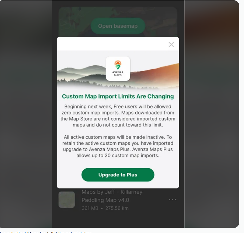
You can no longer download and add georeferenced PDF maps without a paid subscription.
From r/paddling
CalTopo lets you add georeferenced maps, of course, and it is still an excellent tool. But for maps you download from elsewhere, Avenza was a quick-and-dirty option with fewer steps and easier in the field or just on a phone.
For adding georeferenced maps, Field Maps is one suggestion mentioned in the Reddit thread above. I’ve used it a bit for volunteer work, but I’m not overly familiar with it.
Additionally, organizations, companies, and non-profits can no longer update their existing maps or publish new maps. New publishers cannot join the platform either. You can still download maps that already exist in their current state in the map store.
However, it appears Avenza will eventually phase out the map store.
That last point matters.
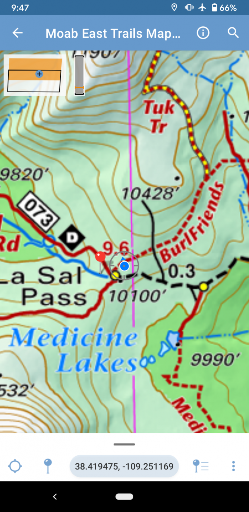
For many small organizations, government agencies, or non-profits, Avenza offered a cost-effective, sometimes free, way to get electronic maps into people’s hands. This fall, for example, I used the Cohos Trail map on Avenza. I assume that the map provides at least some revenue stream for a small non-profit.
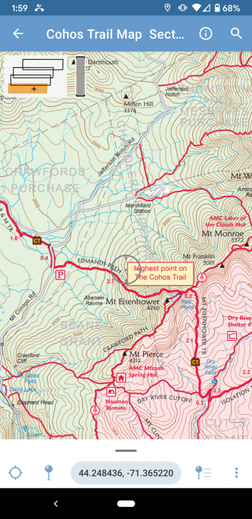
The Cohos Trail is one example. The BLM used Avenza extensively to publish boundary and road classification maps for national monuments and conservation areas; information that’s genuinely hard to find on other platforms. The USFS published their Motor Vehicle Use Maps via the Avenza store. So did the Superior Hiking Trail. So did New York state parks via area hiking groups.
Nonprofits, government agencies at the federal, state, and local levels, and small map companies all found Avenza to be a simple and cost-effective way to distribute maps in electronic format, either for free or at a modest cost.
From what I have seen written, these groups received little to no warning about the change.
That matters because many of these organizations already paid to have maps created for Avenza and do not have money in abundance for yet another layer of distribution.
That quick and easy distribution model was the useful part.
Losing that is more troublesome overall.
So it goes.
Ouch. Phasing out the map store would be bad. Hopefully they will support maps you’ve already purchased…in which case buy a bunch. It should also be noted that the us government lands and the usgs standardized on Avenza for Geopdf display so as long as you can still import those into a premium subscription, you can still use the app.
I far prefer Avenza in VT because Gaia is so bad. Another alternative is OnX which you can buy for specific states and lowers the cost of a nationwide premium subscription.
The map store is getting sunsetted, unfortunately, with no new updates to existing maps. That means Avenza-based electronic maps will become less accurate as the years march on.
The bigger problem is that government agencies on all levels, nonprofits, and small map companies that used the Avenza store now need to scramble for another easy way to distribute this information. In some cases, they may even need to redo the maps on some level.
You had another post about the enshittification of Gaia as well. Do you have any high ranking alternatives at this point for these types of tools?
Avenza is what I’d use for small map companies, nonprofits, or georeferenced maps that are typically free or found online directly. For the latter, Field Maps proved an adequate solution since those are typically overview maps anyway (e.g. the Bears Ears BLM map). The GIS thread I linked has other options as well. However, there is no equivalent of the Avenza map store for small nonprofits or map companies, and as of this date I don’t know of any alternatives. I suspect many of these nonprofits will find their own solutions. Not sure about the map companies. As for Gaia,… Read more »
QField is a powerful open source GIS app available on Android and iOS. It supports full-fledged QGIS projects but also handles opening of standalone georeferenced PDFs without any problem.
It also has a few ways through which authors can share mapping projects, see https://qfield.org/blog/2026/06/18/the-many-ways-to-share-maps-with-friends-teammates-and-the-public-in-qfield/
Disclosure: I wrote that post 🙂
Thx for sharing!
Paul, no worries. It feels like the timing of that blog post couldn’t have been better 🙂
If you end up giving QField a try, let us know how it goes. I’ll be happy to hear about the positives and pain points you’d encounter.
Sounds like a plan. I’ll have to test it out soon and let you all know how it goes. I sincerely appreciate you stopping by my small corner of the web. 🙂
Clicked over from your app post because I was shocked to see the Avenza/Blue Marble situation but when I read further, on this post and elsewhere, it makes sense what happened with some field stuff back in late April/early May we had with our bios out on a project in Wyoming and Avenza failing to work as per usual. I use Global Mapper daily for work (I am the GIS person) and have liked Blue Marble in the past but being acquired by PE makes a lot of sense as to why I was late in getting a license renewal… Read more »
PE seems to ruin a lot. Sigh…
Just wanted to flag one option — full disclosure, I’m the developer.
MapNero gives you 5 free GeoPDF/GeoTIFF imports with offline use at no cost, which directly fills the gap Avenza just created. KML/KMZ/GeoJSON also free. If you need more than 5 maps, Core is $34.99/year — still under what Avenza Plus costs, with no import cap.
Built by a 30-year field professional who hit the same wall. iOS live, Android in testing: mapnero.app