Today I am writing from one of the ubiquitous coffee shops found in Colorado’s Front Range.
I went from the overall sparse population of the Canadian Rockies and returned to one of the fastest growing areas in the US.
The change, as can be imagined, is a bit jarring.
But I am sipping coffee. Typing. And gathering my thoughts.
Some quiet and calm before I leave Colorado for a bit and start a different chapter in my life after almost twenty years here. But that’s another post.
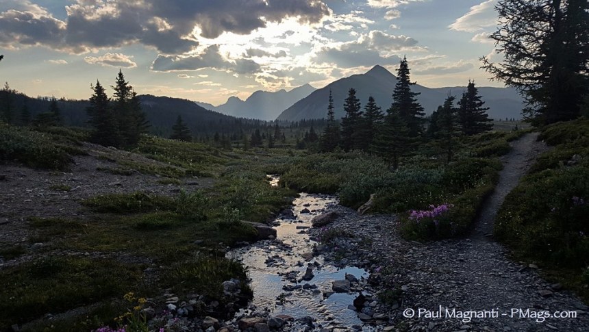
The Great Divide Trail proved to be a demanding physical challenge. And the smoke and fire closures threw some curveballs in that made for routes I did not plan and sometimes obscured views.
But it is indeed about the journey at the end.
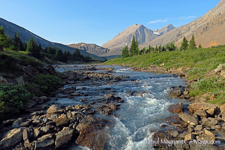
To walk the Canadian Rockies for a month ended up being an incredible experience.
An experience full of wonder and delight with majestic views, glaciers, remoteness, and a sense of wild not typically found in the Colorado Rockies I know so well.
I’d love to go back to the Canadian Rockies again to see what I missed be it because of closures or even the smoke obscuring the views.
But I savored the experience of the GDT and count it among one of my better choices made in life.
The Route Itself

The journey took me 30 days total for the approx 1000 KM from Mt. Robson Provincial Park to the Canada / US Border at Waterton National Park. The caveat is that I suspect my hike ended up being two or possibly three days quicker because of fire closures, walking the jeep, gravel and sometimes paved road alt routes, or even hitching when the closures had no realistic way to connect the steps. I’ll also say up front I will not walk busy paved highways at this point in my hiking career for what I consider to be an excessive distance. A quiet country road, even when paved, has its charms. A busy highway? Not-so-much.
The Great Divide Trail (GDT) is not a beginners route. Navigationally, I did not find the trail difficult. However, a person expecting something such as the PCT, or even the CDT to a lesser extent, in 2018 (increasingly well-marked route, a full-time staff dedicated to trail issues and questions, established permit system, logistic support, trail angel network, etc.) may be a touch disappointed. 🙂 The navigation is more straightforward than canyon country, but it is not a continuously marked trail, either.
More than anything, the GDT is physically challenging. Steep climbs on trails not maintained in a while, or trails that are theoretically there but are overgrown, and, when existing, the tread tends to be rough. Expect long days to do lower mileage. It took me, typically, 12-14 hrs to hike ~35K or so. (On ‘Murican trails, I’ll usually do ~25-30 MPD. On my Utah walk in the Fall of 2017, I did about 20-25 MPD as well, but with fewer daylight hours and had more camp time.) I think most people experience about 20% drop in distance covered off their typical average on a more established trail and take longer do this reduced distance. At least that is my unscientific gut feeling based on talking to other GDTers and seeing what people post after the trip.
Not a complaint about the GDT. But an observation any potential GDT hiker should be aware of before starting out.
Overall, I found the northern half to be more physically challenging. South of Banff less so.
I should note that the GDTA completed major trail projects during my hike and shortly after. Other major projects are on tap for 2019 and beyond. The GDT is a dynamic trail and constantly evolving. Exciting times ahead!
Planning

The Great Divide Trail Association has an excellent website with town info, travel info, etc.
- The town info has just enough of the basics for an experienced long-distance hiker to figure out what services are available in a given town. There is no extensive town guide listing known good restaurants, prices for hotels, etc. Probably not a need for one at this point, either IMO. I suspect as more people hike the GDT, and more people want detailed info, some enterprising person will come out with this type of resource.
- The Trail and Closure section of the GDTA website ended up being extremely useful in this year of fires, smoke, and closures. Alas. 🙁
- The Access page is dialed-in with helpful info to reach the various places and termini along the GDT. With Greyhound ending service to some areas, check this page for updates in the coming months if you are planning a GDT thru or section hike in 2019.
The GDT Hikers page on Facebook is very active. Very knowledgeable people and lots of collaboration among current and past hikers. The GDTA also posts on this page. A useful Facebook page! Who woulda thunk it?!?!? 😀
Maps and Navigation

On one of the older established stretches of the GDT, some markers and blazes exist! 🙂
As mentioned, I did not find the navigation particularly tricky on the GDT. For a person experienced with reading a map, the mainly macro level navigation is not hard. I found the Ryan Silk GDT maps to work out well enough to follow the GDT.
The Atlas (Guthook) GDT Guide app is handy with guidebook-like notes within the app itself and of course, helps a person to stay on the route.
My typical navigation challenge ended up being disappearing and overgrown tread. Esp. in meadows or woods with many blowdowns. A mixture of the new school (finding the track on the GDT app) and the old school (taking a compass bearing to get to where the tread can be seen faintly, but more comfortable to walk than straight up bushwhacking) proved to be the combo I used most.
In the Howse River section, taking the suggestion of ceasing to look for the trail and walk the river instead ended up being the most judicious way of making progress. Mainly due to all the blowdowns that numbered in the hundreds per the GDT app text author.

Quite stunning, too.
If I did it again, I’d take some overview maps such as the Gemtrek series. I did use a Banff National Park map to plan out an alternate route due to one closure. Something similar would have been used towards the end of my trip when there were additional fire closures. The NatGeo Adventure Map series is an inexpensive alternative to map atlases, with enough overview information I find for general planning. Worked well for me in Texas and Oklahoma. I did not use it, but I suspect the NatGeo Canada West Adventure Map, combined with my Gaia GPS app, would have been an excellent resource for alt route planning when the closures happened. Easier than planning on my phone only!
Permits

On the Skyline Trail in Jasper NP.
As with my Utah trek, I did the spirit rather than the letter of the law when it came to backcountry permits. Being on foot with variable dates, difficult to get the exact dates and places. But I always had a permit. And I did purchase an individual parks pass at the MEC in Calgary. (MEC is essentially the Canadian version of REI). Paying for the entrance fees did not end up being an issue.
Some additional notes:
- The Skyline Trail is very busy. Easy to see why. A world-famous trail in good condition. However, this portion of the GDT is where an experienced hiker with a light back could hike that portion of the trail in a day. I lucked out and a young couple, very scared of bears, changed their mind about doing the Skyline Trail. When they heard me in the parks office ask about the Skyline Trail (and listened to the obvious answer about availability! 😀), they offered me their spot. A low distance day, but I had a great evening with some cool folks. And easy day, esp with a full pack out of town, can be a good thing once in a while!
- The Rockwall Trail is the other place where finding a camping spot is apparently difficult. However, a fire closure blocked that access for me. I can’t comment too much on those particular logistics. Allegedly dispersed camping is available on the BC side per the app guidebook text. But, again, I don’t know from personal experience and can’t comment.
- The Provincial Parks and National Parks always had spaces available at the campsites when I showed up later in the evening.
Issues
Compared to Utah, the issues (in my opinion) were not overly complicated with one very major exception. I rarely carried more than a liter of water at the most, navigation did not prove to be terribly difficult, and the trail was kinder on gear than the sand. That’s not to say there were no issues faced that if not unique to the GDT vs. other trail or routes, indeed was on the mind, though.
- Grizzly bears are the “issue” people ALWAYS voiced concern about. And people are petrified of them! I heard more bear bells in one month than in my life total, saw people walking in the campsites with bear spray, and people expressed concern that I chose to hike solo. I am not going to downplay caution in grizzly territory, but being cautious worked for me. Unless in an established camp, I never ate and slept in the exact same place, used an Ursack and Opsak combo, and when I did see three grizzlies in one day, I kept my distance. When a male griz noticed me and let me know he did not appreciate me being in his territory, I walked well way and waited until he was satisfied and left the trail. I did not take bear spray, I hiked solo, and wore no bells. YMMV. If you decide bear spray is warranted, purchase once in Canada. Generally, you can’t fly with this equipment. The MEC in Calgary has bear spray readily available.

I only took this one shot before he noted his displeasure. I apologize for the framing. A second shot did not seem wise. 🙂
- Stream fords are the primary issue up north, not grizzlies, in my opinion. Glacier stream fords in particular esp. in the afternoons or earlier in the season. Look upstream and try to hike in smaller channels that have gravel obvious. Use hiking poles to “scout” the steps ahead. And when uncomfortable, turn around! Worse case? Call it a day and cross in the morning when the flow from the glacier melt is lessened, and the crossing is safer. In some cases, such as the video posted above, a makeshift bridge of sorts is available and put in place by previous hikers. Check the stability as you go along!

You will cross the Moose River many times!
- Fire, smoke, and closures are the other major pain points I encountered. And by far what affected my trip the most. Check both the GDTA conditions page, and the GDT Hikers page mentioned above for information on closures and possible reroutes. Consult your maps as you will need to do your own planning in many cases, too. I’m afraid the new normal is going to be yearly closures all over the North American West unless we are lucky enough to get an occasional wet year. At least IMO. Be prepared. As a side note, when I finished the GDT, I woke up two nights in a row from very realistic dreams that I thought were real. Both nights, my dreams consisted of looking at maps to find a practical route around fire closures. I guess I know what was on my mind that last week! 🙂
Gear

Mt. Robson peeking out near the start of my journey.
I know people are going to have gear questions, so here is a summary of some particularly useful equipment or related tools:
- I wore my Montbell Versalite quite a bit for the first half. Fairly breathable by itself. But the pit zips help immensely! All in a 6 oz. package. Highly unusual for very light jackets. More durable than my Frogg Toggs, too. Good for the short spurts of bushwhacking! A more robust jacket is perhaps better for the constant wearing of rain gear esp when bushwhacking. But the Versalite did quite well for me on the GDT. I’ll write a more thorough review in the coming weeks. The overall view? Expensive when compared to other alternatives. But if the jacket is in your budget, it works like all Montbell gear: Well designed and functional gear that works as their motto states: Function is Beauty. (Disclosure: Montbell US provided the jacket to me. But I’ve been using Montbell clothing since 2006 on a regular basis. All purchased with my funds except for the rain jacket discussed above and the light puffy I received for volunteer work a few years ago.)
- Long pants worked well up north with the more common blowdowns and cooler, rainier, weather. Hotter and drier conditions south of Banff, with better and more clear route conditions, made me wish for shorts. Overall, I am glad I took long pants overall, however.
- OTOH, I took my usual windpants. With the overgrown willows that soaks you quite a bit, the blowdowns, and the cold rain had me wish for real rain pants versus down here in the Colorado Rockies. So it goes. Live and learn. Not a deal breaker. But would have been nice to have real rain pants! Though I liked the Versalite jacket above, I would not trust the Versalite pants for some of the willow bashings and log hopping. I find pants take more of a beating than jackets. Something like the Red Ledge Thunderlight is about 9 oz for a Men’s Medium and only ~$35 for some bargain, but still effective rain pants. Buck Nelson these pants for both his Alaska Traverse and his Brooks Range crossings. There are other options, of course.
- A simple baseplate compass is a piece of gear I used reasonably frequently in conjunction with the GDT phone app. More so in the northern part of the trail. The phone app would show where the track is located. A compass bearing would get me to the faint trail. Even a faint path, though hard to follow (and sometimes why I lost it), is easier than going cross country through downed trees. Simple, inexpensive, and it works. Get one!
- Speaking of phone apps, the Atlas Guides (Guthook) GDT app is a tool that I found to be well designed, helpful, and though not needed to hike the trail, certainly made things easier at times. The guidebook-like notes within the app are something I consulted daily. I’ll write a more thorough review in the coming weeks. Disclosure: Atlas Guides provided the GDT app to me at no cost.
- I did not use a stove on the GDT and went with cold food instead. Why? Because flying with a stove can be a pain many times. And with the long daylight hours, easier to eat small meals throughout the day and hike to 9 or even 10 PM. Due to grizzly activity, eating where I slept did not make sense and, for me, cold food is simple when “on the go.”
- UPDATE: The Salomon X Ultra 3 hiking shoes proved up to the challenge of the rougher trail. I bought them around Banff, and they were still in good condition 300 miles later. The shoes are good for hiking beyond trails, and I’ve grown to love them for off-trail jaunts in canyons or mountains in Utah. At $120, very reasonable in price for the versatility.
If you still have gear questions, please see my (more or less) current gear list.
Trail Culture

My friends Naomi and Mike. We met on a dirt road that is part of the GDT. I headed south; they headed north.
About 50 people stated their intent to hike the GDT in 2018 and with a smattering of section hikers, too.
There is no herd or bubble. And bumping into other GDT hikers is usually fleeting.
I went south for logistic reasons and I met one fellow southbounder. We spent a morning shooting the breeze at The Crossing before I headed out again.
If you hike the GDT, you will be out there by yourself or with your partner only often times. In popular provincial parks and national parks, you’ll see other backpackers of course. They just won’t be GDT hikers.
The GDT Hiker page on Facebook is where the community tends to be most visible.
Misc
- Alt routes are available. Usually, ridgeline walks above treeline. Most involve non-technical scrambling. I did not hike the more ambitious alternates myself so I can’t comment too much. My reasons? Smoke obscuring views lessened the appeal of off-route options, I often hike off-trail at home and did not feel the need as much on the GDT, and my last long walk in Utah in the Fall of 2017 was essentially one long alternate route. For the GDT, my goal was to hike something more defined with fewer navigation challenges. On the other hand, the photos I’ve seen of the alt routes looked awesome. YMMV.
- I’ll be writing a Quick and Dirty Guide to the GDT that summarizes much of the information even more. With a less personal and more general backpacking focus, of course. ETA?
Sometime in September.PUBLISHED!
- The Great Divide Trail Association is doing a fantastic job of starting to get the word out there for the GDT, beginning to work with national parks, performing more and more trail work, and helping to make the GDT a crown jewel of a Canadian wilderness experience. Consider joining the organization if you have any interesting in hiking all or part of the GDT!
- The Great Divide Trail is the right trail for someone who enjoys a challenge, thrives on a sense of the wild, wants to see world-class scenery, and is not expecting a connect-the-dots trail experience. If that sounds like something you’d like, get out there and do it!
Highlights in photos
Here are some highlights of my trip via photos:

Columbine

A glacier at Robson. Foggy day, but still impressive.

Moose Pass

Mamma Griz and cub


Bighorns in Banff NP

Cuddling marmots


The closures did let me see a small town parade. Complete with Mounties!

Dock at Glacier/Waterton

The end of one journey. Same place where I started another in 2006.
Want more? See all the photos here!
(Why are the images on Flickr only 1024×768 or so? Besides taking a long time to upload that many pictures at the highest res avail, very few people upload the highest res photos online. Esp. in this day of mainly smart devices and social media use, along with easily copied content. Hi-res photos are for presentations, gifts, non-profit use, and commercial use typically. )
All the entries
I have multiple entries with more thoughts, more planning info, and of course more photos.
Nice pictures and much thanks for letting us see the Divide through your eyes!
My pleasure!
Great post. My wife and I just got back from being those “traditional backpackers” going up to Robson from the trailhead. Amazing views, made somewhat less stunning by all the smoke. I think we had about 2 days of decent visibility bracketed by lots of smoke obscured hiking.
Even with the smoke, the Canadian Rockies delighted. A tough trip for me with various curveballs (smoke and fires being the most obvious!), but an experience I do not regret! The two places I want to go back to see again are Robson (weather) and Peter Lougheed Provincial Park (smoke)
Put the Rockwall on that list – it’s a bigtime highlight of the GDT.
Noted!
Gorgeous shots! Thanks for sharing your adventure for the rest of us “desk jockeys” and “weekend warriors”!!
Thanks! Glad you enjoyed my journey!
Nice hike, good report, great photos Mags!
Thanks for sharing the trail Paul and passing along info to future hikers!
The GDT is getting better every year with new 50km of trail to replace roads in Section B (heading into Coleman) opening in a year or two, clearing of the David Thompson Heritage Trail last weekend and a new alternate that will avoid the willows in Section D. It’s amazing to see all the passionate people involved in restoring and developing the trail.
Lots of great stuff happening for sure. Amazing!