A backpacking trip to the Grape Creek Wilderness Study Areas.
It is now the end of April. The foothills are rapidly losing what snow they have. The streams are swollen with snow melt from the high country.
Spring is here at the lower elevations.
Time to put away the skis. Swap out my winter gear for three-season gear and start to get ready for backpacking season.
Getting the itch to get out this past weekend, I explored an area I’ve heard about but have never been to: The Grape Creek Wilderness Study Areas.
A transition area between the arid flat lands outside of Canon City and the Wet Mountains upstream.
As with all transitional zones, it would prove to be interesting. For a quick overnighter, it was delightful. And a perfect trip to kick off the backpacking season.
Since the trip was on the shorter side (perhaps 16 miles R/T), I left later in the morning from Boulder.
I made my way down Interstate 25 and through the Denver sprawl. Exited the highway outside of Colorado Springs and made my way past Ft. Carson.
The land became sparsely settled and more rural in character.
I entered national forest land and then crossed over into BLM land on a somewhat rough and rutted dirt road.
A nondescript dead-end and a weathered sign marked the trailhead.
My pack was hoisted. And I then entered the WSA.

Grape Creek meandered down the canyon. The stream would be a companion for the weekend.
Though there are no maintained trails in the canyon, this somewhat popular area had an obvious social trail in many places. Since a narrow gauge railroad went through the canyon in times past, the social trails often followed the old rail bed.

I soon reached an area called “The Tights” that was labeled on my map.
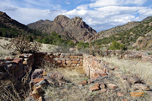
I climbed up a flat shelf and enjoyed the views of the canyon below.
On this shelf, the foundation of old mining buildings was spotted.
I made my down and back into the canyon. The walls became steeper and the creek narrower.

The canyon opened up. Grape Creek become wider and a little more shallow.

The skies were clouding up and rain was threatening.
Couple these facts with a private parcel of land that was perhaps a half-mile down the creek (and, according to the BLM site, now closed to the public), figured it was a good time as any to call it day.
My tarp was set up. The sound of the rain on my shelter lulled me to sleep.
The following morning, I woke up to sunny skies and the canyon lit brilliantly in the spring time sun.

I climbed out of the canyon and made my way on a railroad bed that was well-defined in this part of the canyon.

Along the way, I spotted some colorful western wallflower.

I made my way back upstream. The dozen people I saw yesterday, all fishing but me, were gone on this Easter Sunday. Only the remnants of their campfires remained.
Just before I reached my exit point from the canyon, I took one last look downstream.

A glorious spring day, a flowing stream and red rocks in the canyon.
What better way to start the backpacking season?
The Details
- Directions here. The last three miles are on a rough dirt road. A higher clearance vehicle is suggested. Though, I did see a mid-1990s vintage Chevy Cavalier at the trail head. Drive slowly if you do take a 2WD passenger car.
- Map : Use your topo software of choice.
- Other notes: A decent amount of people were at the start of the canyon; less so as I made my way downstream towards the private parcel. A popular fishing area. I was the only non-fisherman. Based on the amount of fire rings spotted, a locals favorite for camping/fishing/backpacking. Open year round per this document.
Thanks for this trip report. I going to explore this are or another near Canon City in early May this year.
Did you just do an out and back? How many miles in?
About 16 miles R/T.
So 8 in, camp, 8 back out?
Yep. A mellow overnight.