There is one national park that has always been a must-see for me. A park among the least visited in the lower-48 and in a place I do not know well.
That national park? Big Bend in Texas.
Because I have given myself the gift of time, I finally had the opportunity to see this gem of the national park system.
I wanted to see the canyons, see the Rio Grande along the Mexican border, climb up in the mountains, and go back to the desert floor. And enjoy what is supposed to be one of the most glorious of night skies found in the national parks.
Texas is not a state known well to me.
My previous Texas experience (before 2017) was working as an IT Support Monkey for a former employer’s trade show. I do not count that visit as I only saw the airport and a generic convention center hotel.
Then I went to Palo Duro State Park this past February. Amazing! I thoroughly enjoyed my time there and knew Texas had more to offer.

Welcome to Texas!
And on this trip, I planned on seeing more of those gems. Big Bend of course, but others, too.
The first of these others? Guadalupe Mountains National Park.
Most well-known for Guadalupe Peak as the Texas State high point.

On the way up to the summit
There is much more to explore to this park than just the high point of course. A Fall backpacking trip would be exquisite with paths usually not taken by most. And blazing with autumnal color.
But for this trip, I would hit the literal high point of the park. Car camping and day hiking would be the mode for my first visit here.

View of Hunter Peak from my campsite later that evening
After procuring my site, I quickly laced up my trail runners and went up the trail. A light day pack, trail runners, and still being in good shape after my Utah walk meant I made a great time up the trail. Or so people commented. 🙂 I did the same pace everyone did, of course: One step at a time! 😉
The trail was well graded, easy to follow, and at 8 miles round trip and 3000′ gain, a lovely and limber jaunt.
The weather was perfect on the summit. No wind, blue skies, and only a light fleece needed to soak in the view and enjoy my lunch.

Summit of Guadalupe

I headed back down and then took in the nature walks around the visitor center. I even saw remnants of an old Butterfield stage stop with the mountains forming a backdrop.

Though the campground was not far from the road, the NPS has done an excellent job of carving out sites where the road is not in site. Nor are the other campers noticeable.
Still, I need to come back to this park and explore it more via the lightly used backpacking trails.
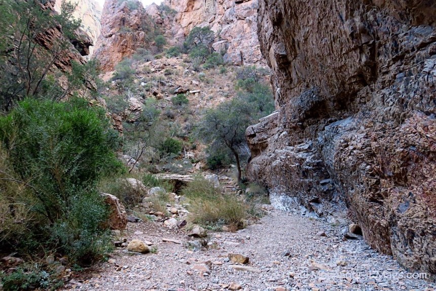
With those thoughts in mind, I made my way through the lonely Texas highways (with a pitstop for BBQ at a cash only place in Alpine, TX. Mmmmmm….) and made it to Big Bend!
I was giddy. No other word to describe it. These reasons are why I am taking my road trip: To see places I always thought “someday I’ll see them,” except now I making these “someday” thoughts reality!
Big Bend was a National Park similar to the ones I love in Utah: A long drive to get there, on isolated roads, massive in size, with lots of true backcountry.
Sure, that park is regulated as any other NPS unit. To be expected. But I had the feeling of the Utah wildlands I enjoy. The maps showed possibilities. And one trip would not be enough to see them all!
But I’d do my best to see what I could.
My timing was excellent as I just missed the busy Christmas time rush. And the snows of last week!
I made it to the ranger station with more than enough time to get a backcountry permit and also to find a car camping site that evening. For my first time at Big Bend, I knew that some backpacking would have to be done. A park as large in scope as Big Bend is best appreciated by backpacking.
And what loop to do? The Outer Mountain Loop is the classic one of course. A perfect introduction to the mountain and desert ecosystems of the park. But I did not want to deal with red tape, having my typical mileage being called reckless, or deal with the semi-mandatory water caches. But then I looked at the map. Ah ha! Dispersed camping zones!
I applied for and received a permit in the dispersed zone. I truthfully told the ranger that the reason I wanted this option was that with fewer daylight hours, I did not know how far I would get that evening. I just did not tell her that meant, depending on my start time, 18-22 miles. 😀
Permit procured, I camped in the nearby Chisos Basin campground. A bit more populated than I would usually care for, it did have the charm of being near a great little hiking trail with a view to The Window. At ~4 miles R/T, perfect to stretch the legs just before sunset.
The views at The Window did not disappoint.


A little love is shown at the park…
The light show put on the way back was also memorable.

What a great start for my first time at this park!
The following morning I drove up to the Chisos Basin trailhead, hoisted my pack, and made my way up and over the mountains to start my trek to the desert floor below.

I lost about 3000′ of elevation. And the differences from the pines above at 7000’+ feet to the desert plant life below was striking.


I only saw three other hikers that day once I passed the mountain ridges. Even with the dirt roads nearby, I still felt as if I was in more of a backcountry area. Again, visions of Utah were conjured up regarding the feel of the trip.
My hunch about water being in potholes due to all the snow was correct. And a listed spring had water as well. Even without the bonus water, I would have been fine. But I’ve learned to appreciate this extra water after my trip last month!
It was soon getting near sunset. I spied a place in the distance that looked good for an evening camp.
And the views from camp did not disappoint.

The sunset view continued to entrance.

And that evening? I caught the very start of the Geminid meteor shower. More good timing!
I made way up into the Chisos Mountains the following day. With good NPS grade tread, the distance was covered easily. I could simply enjoy the views.

The top of the canyon rim area was reached. I opted for a favorite variation of this loop that takes in the Southeast Rim. A touch longer than the classic route, but very scenic.

I soon started my descent back into Chisos Basin proper. Some last views were savored.

I reached my car, enjoyed a cold ice tea from my cooler, and went to the visitor center to report to the volunteers staffing the office. A condition of being solo listed on my permit.
The very helpful volunteers were able to get me a primitive 4WD campsite by the Rio Grande…at no extra cost. Fantastic! An excellent way to wrap up my trip.
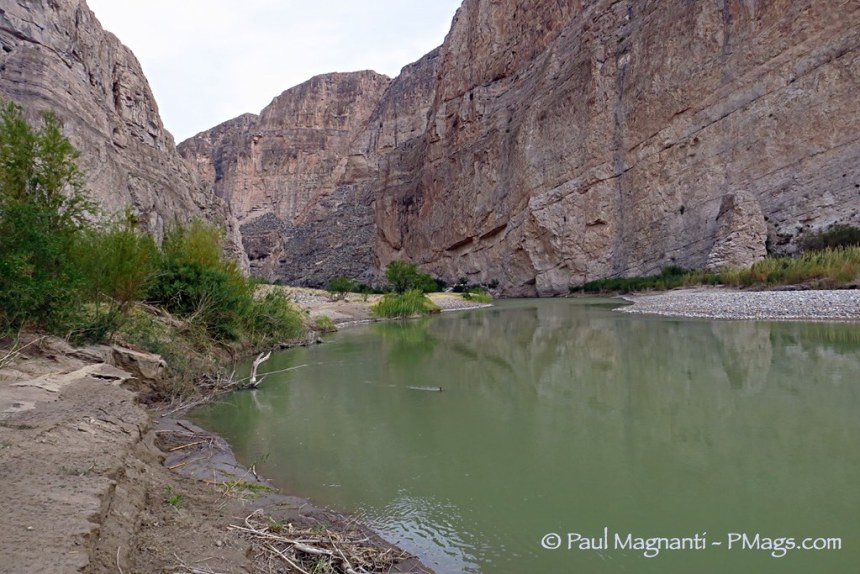
Though my actual site was sheltered from the river, a very short walk did give me a commanding view of the Rio Grande.

The Rio Grande. Mexico is on the right-hand side at the river bank.
Mexico was in sight. Hard to believe that such a contentious border was only separated by a thin, shallow, river.
That night I heard coyotes yipping. And burros braying from the Mexican side of the river! Though overcast, I did see more of the meteor shower that evening.

Fossilized imprint by the river. Many fossils have been found in the park. Some rather large! https://www.nps.gov/bibe/learn/nature/fossils.htm
The following day I wanted to explore the river areas more. I did a short hike to Boquilla Canyon.
From a bluff, the river and the international boundary could again be seen.

A short semi-scramble brought me to where the cliffs started. I would need a raft to go further. I won’t get into politics, but I’ll just say that the thought of a wall here is ludicrous.
On the Mexican side of the river, I saw rowboats and canoes. An unofficial market is left on the US side of the river. Goods are sold by an honor system. And they come from the namesake town of Boquillas only a mile or two up from the canyon.

After this short hike, I decided to go to Mexico and visit Boquillas. A simple process: Bring my passport, have the NPS employee tell me the Dos and Dont’s at the border station, pay $5 to the locals to ferry me across the Rio Grande, walk the half mile into town, and there I was, in Mexico.
Except, well, it wasn’t so simple for over a decade. Post-9/11 security concerns ended this border crossing until 2013. And the economy is only now starting to recover. And what was once a fluid cultural and environment area is now still artificially separated in some ways. So it goes. An International Peace Park ala Glacier and Waterton was proposed at various points as far back as 1935. Things have changed in recent years…

Looking over the Rio Grande into America.
Once in Mexico, I strolled through town. I did not buy any knickknacks. I just wanted to take in the town. This old mining town is still apparently recovering from 12+ years of their economic livelihood being gone. But there were signs of economic vitality returning. A newer looking school, solar panels installed that apparently supply the village with its electricity, etc. I entered the humble Catholic church and recognized a place not far removed from my upbringing.
I then wandered to the edge of town where most Americans do not go apparently. A local was surprised to see me. Between his basic English and my using of my very rusty and basic Italian that had echoes of Spanish, we were able to have a conversation of sorts. He said most Americans don’t enjoy walking. Ha! True... He also laughed when he realized I was trying to use Italian words that sounded like Spanish. 🙂 He showed me his home, his chickens, introduced his wife, showed the adobe wall he was constructing, and a local hot spring by his house. A very memorable experience.
I grabbed lunch and was surprised (again, being a tourist town) at how tasty my poblano chile was at the restaurant. And reasonably priced as well. Overlooking the river, eating my food, and enjoying a beer, it was not a bad way to pass an afternoon.
But it was time to go.
I returned across the river, reported to customs remotely in El Paso, and was cleared to be back in the US.
I showered, did laundry, and slowly made my way out of the park.
The surface of the park was only explored. So much to see in this remarkable area. One trip was not enough. I thoroughly enjoyed Big Bend and need to return. The map is big and holds so many promises that I need to keep for myself.
Awesome, looks like the weather really cooperated for you. Big Bend has been on my list for years, but it is so far away from everything, probably why I have not made it yet 🙂 And Mexico to top it off, perfect.
Not sure where your future travels are taking you, but if you pass by Chattanooga, check out Savage Gulf State Park, probably no solitude, but really cool water and rocks and a good place to spend a day or two exploring. I was just there last week for the first time, definitely won’t be the last time.
Glad you saw these. I’ve lived in Texas for many years but didn’t see these until the last year or so. Rugged and beautiful. The bowl area north of Guadalupe peak is really nice – lots of pines and reminds me of Colorado somewhat – with one of the biggest differences being no water :). Also, there is one “long distance” thru-hiking trail in Texas called the Lone Star Hiking Trail. It is not as scenic as Guadalupe and Big Bend but it is 128 miles long in the Sam Houston National Forest north of Houston. Obviously nothing like the… Read more »
Big Bend is such an amazing place and I try to get out there at least once a year. Any plans on heading back there in the future?
I hope to in the next few months!