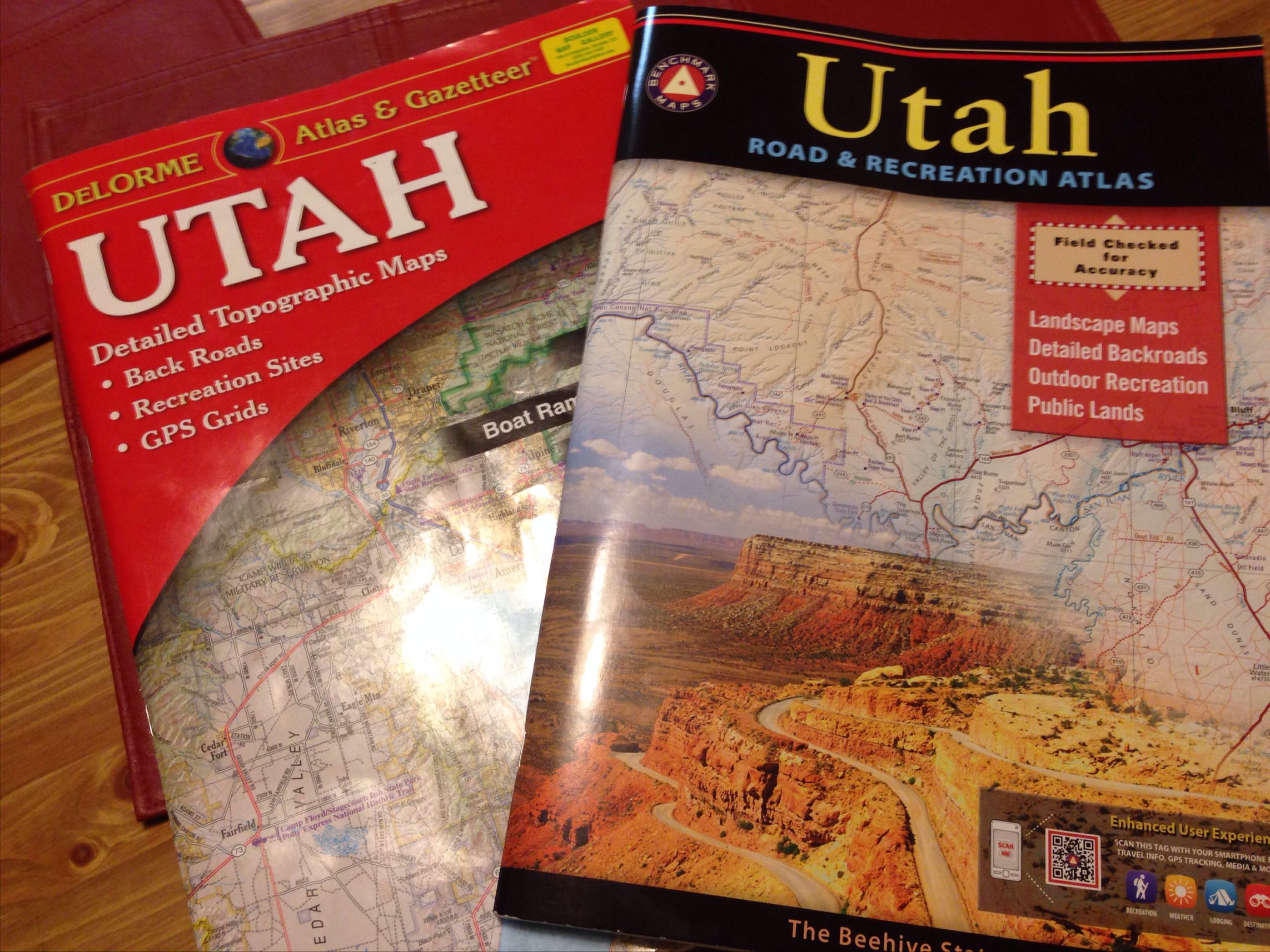
There are two standards for backcountry road navigation. The Delorme Atlas and Gazetteer and the Benchmark Road and Recreation Atlas. Which is better?

When I am on any kind of backcountry trip, I always take maps. Not only do I simply like maps, they are also a necessary tool. Despite the prevalence of smart phone apps, GPS devices or even being on a well-marked trail, I find a map is needed. For off-trail hiking especially, there is no real substitute for the appropriate map.
Other devices and tools may help you stay on route, but a map will let you plan and alter your route much easier.
Likewise, getting to a more obscure trailhead or navigating backcountry FS or BLM roads, a map is still needed. An automotive-based GPS does not always have the necessary data for non-city driving and relying on a cell phone is never a good idea.
So the answer is a road atlas. Not the Rand McNally atlas for highways and city roads (which I also make use of), but rather a road atlas with more detail needed for the backcountry areas. Something that shows not only the fabled blue highways, but also the brown (dirt) ones, local landmarks and other geographical information.
If I am going to an obscure pueblo in Utah or even a trail head, I need this type of detail.
A Rand McNally will not have the right detail and a topo or a typical commercial hiking map will not necessarily give the broader overview I need for this “in-between” navigation.
The answer for many years was, and still is, a Delorme Gazetteer and Atlas. This Maine-based company is nearly 40 yrs old and is very much a part of many outdoor enthusiasts gear kit. Countless Delorme atlases are stashed under seats, have wrinkled edges, some slight dirt stains and fine grains of sand from countless trips done or planned on the fly for the backcountry. Backpackers plot out the best place to start their hike of a canyon, hunters pick out the best dirt road access to set up an elk camp, mountain bikers plan out their route on obscure jeep roads and many ATVers consider these atlases as much part of their kit as a good helmet.
Outdoor enthusiasts can sometimes be a divided lot. But the need for good maps is a constant. And the Delorme atlases has filled that niche for many years.
For-not-quite 20 years, a new company has steadily become a competitor and alternative to the Delorme series: the Benchmark Road and Recreation Atlas series. This Oregon-based company does not have as many atlases as Delorme, but has developed an ardent following for the western part of the US.
So, which version is better?
The answer, as usual, is never clear-cut. But here’s my take.
Keep in mind, my focus is on backcountry use. I primarily use these atlases to get to trail heads and to scope out the occasional primitive camping site. Someone into ATVing, MTBikng or a more frequent primitive camper than I am (or even using a small RV) may have a different take.
(Note: My circa-2002 scanner is packed away and my iPhone photos stunk. So I shamelessly stole the photos via Google Image Search!)
Delorme Gazetteer and Atlas
What I like:
- Very good detail. The scale is larger. Think 7.5 minute topo vs a commercial hiking map. Good if hiking something like the CDT and need to know bail out points and alternate routes
- Topo lines. Easier to see how steep a road or an approach may be since I am used to reading maps.
- I like the road designation system used by Delorme. To me, it is very intuitive to see which road is paved vs dirt vs a rough jeep road vs a VERY rough jeep road
- Slightly less expensive than the Benchmark series
What I don’t like
- Inconsistent. Some roads on the map have different numbers than what is “on the ground” or even have no numbers at all. On our recent Utah trip, there were road numbers visible on signs from the road we were currently on, but no road numbers listed on the Gazetteer!
- Other users report just plain wrong info. Some roads don’t exist, others do exist but are in better condition then what is reported on the map

Benchmark Road and Recreation Atlas
What I like:
- Smaller scale which is good for a larger overview. More features such as campsites, oil wells, reservoirs, local businesses, landmarks, etc. oddly enough on the maps themselves despite the smaller scale
- Shaded relief is easy and quick to read at times
- Features stand out more. Also makes it easy to read.
- Seems to be more accurate as the road numbers were not only listed, but reflected what was “on the ground” as well. The roads names on the map matched up with the local names, too
- Lots of extra info: Indexed towns, natural points listed, ,campsites, etc.
What I did not like
- I miss the topo lines
- To me, the road designations on the Delorme are more intuitive. Admittedly, that could be just because I am used to the Delorme. someone actually picked up the road types quicker than me on the Benchmark. Her experience with the Delorme is limited.

So…which one do I like? The Benchmark is better for general navigation. The Delorme is better if I need more details in terms of topography vs road information.
If I had to pick just one, I’d go with the Benchmark. The ease of reading, apparent accuracy and features make it the better choice of the two atlases in my opinion.
In reality, I like them both as they complement each other. The Benchmark and Delorme series tend to show things in different ways and sometimes have different information.
Though ~$40 for two books may seem somewhat pricey, considering I tend to keep these map books for about five years or so before I update them, the overall price is not that expensive.
I suspect the Benchmark series will be my primary backcountry road atlas going forward and the Delorme my supplementary one. In a side by side comparison on our most recent trip, the Utah Benchmark was the one we tended to consult more often than not.
EDIT – MAY 2015: In the past year, I’ve grown to love the Benchmark series. I lament when Benchmark does NOT have a map for a state. When the Mrs and I went to the Pawnee National Grassland recently, the Benchmark made it very easy to navigate the maze of roads in this area vs five years ago with the Delorme.
Good info. I have been used to the DeLorme ( moved here from Maine) and wondered about the Benchmark. One can’t have too many maps, although the quantity we own really amuses my wife.
I agree. “Too many maps” just does not exist as a concept. 😉
I recommend to people to buy both if they can and to buy the Benchmark if they only get one. I live in Washington and where the Delorme falls down is not making enough distinction between paved and dirt roads,The Benchmark is very accurate on this so if I am driving a regular 2wd car I can plot my course to stay on pavement if I need to. Having both does increase the information choices and as the author said they do complement each other and I travel with both all the time.
I tend to agree with your statements.
There are only two limits to the amount of maps; those you can afford & the weight of those to carry. No such things as to many when planning. A tow job in the back country cost far more than an accurate map or two, or more. I’ve seen gps take people on backroads when they were 1/4 mile from the interstate.
I found this article very interesting. My preference has been with the Benchmarks for about 5 years now but I am disappointed that they only have a limited number of states represented. Delormes are very good as well, as I mainly travel Appalachia and do not cross the Mississippi often.
Only 12 states, but with the new Alaska one, well over 1/3rd of the total land area of the US and well over 50% of the public lands mapped. Wowsers…
Probably more useful for the Western US admittedly.
Really good information here. I’m planing a cycling tour from Seattle to Bar Harbor, ME and I’ll spend some time on gravel roads in Montana. This post help me decided to go with Benchmark.
Have a great bike tour!
Ever since I discovered Benchmark maps 6 years ago, there is no going back. The best. 35 mile dirt roads? Check. Rustic car camping got so much better. I found places a never dreamed I’d stumble across. I write all over it, like trip notes. Really useful in the future. Benchmark = the bomb.
Thank you so much for the information, you pointed me towards just what I was looking for! I just got into doing dispersed camping, and trying to use a regular map/phone with gps was not cutting it.
Do these atlases mark BLM land as well, or just national forests/parks/etc?
Thanks again!
Both show the BLM lands in addition to USFS/ state lands, etc. Handy!
Hi Paul, Thanks very much for the excellent review and to everyone for your positive comments. We were just pointed to this article and I’d like to speak to a few items for your readers: -The accuracy of map and POI content in Benchmark’s Road & Recreation Atlas series is a credit to our field-checkers having driven tens of thousands of miles in each western state since the mid-1990s. -Benchmark’s team of cartographers in Medford, Oregon is world class, having won several national & international awards. Their talents blend many data sources and design techniques to produce maps that present… Read more »
Bridger,
Thanks for stopping by my neck of the virtual woods!
Has Benchmark thought of adding the Dakotas for the atlases? A lot of Westerners go to the Badlands, the Blackhills, Theodore Roosevelt NP, etc and would love the Benchmark quality for these areas.
Keep up the excellent work.
My boyfriend recently acquired the reportedly most recent New Mexico Delorme map. There were a lot of errors in it. Roads that of been in existence for five or 10 years were not marked and other roads they had on the map didn’t exist or had been significantly changed over the last 5 to 10 years and this was the most recent addition. It does say you couldn’t let them know but I’m not sure if they pay much attention .
As mentioned, I prefer the Benchmark. The New Mexico one has worked well for me.
Thanks for the great info and comparison of these two atlas products. I live in Arizona, and am looking to get a detailed atlas of the state. One thing that is incredibly important here in AZ are detailed map features of Tribal lands. For example, the Navajo Nation is one the largest sovereign nations in the United States, and they allow backcountry use, visitation, and dispersed camping (with a valid Navaho Nation backcountry permit). There are many Tribal road networks in the the Navajo backcountry that can take you out to some incredible places. Some topo maps are useful for… Read more »
Hi Matthew,
I am not familiar with the AZ Delorme, but the AZ (and NM for that matter) Benchmarks show the tribal lands and roads. And are designated as such. Here’s a quick snap. Hope this answers the question. Now that I am in Utah, I’ll have to check out the AZ Navajo land options!
I appreciate your comments. I live in Texas and DeLorme has been the only choice up until now (2019). I am getting ready to add the Benchmark (New Mexico, Colorado, and Texas) atlases to my collection. Traveling Forest Service roads in Colorado really requires good maps. I used a DeLorme to follow the Continental Divide in my Honda CRV. For the most part it was okay, but the missing road labels caused a few errors.
I am so glad I found this site.
Glad it helped!
Im expanding my portfolio for the time in the near future when GPS is no longer available and/or I have to migrate to someplace safer. This comparison was ideal and done very well. A thousand thanks.